


Journal of Agricultural Science and Technology ›› 2025, Vol. 27 ›› Issue (4): 230-238.DOI: 10.13304/j.nykjdb.2023.0722
• BIO-MANUFACTURING & RESOURCE AND ECOLOGY • Previous Articles
Bo ZHANG1( ), Yanghuan LUO2, Lang LI3, Hengfei LIANG4, Jiamin HU1()
Received:2023-09-27
Accepted:2023-12-04
Online:2025-04-15
Published:2025-04-15
Contact:
Jiamin HU
张波1(), 罗阳欢2, 李浪3, 梁恒飞4, 胡家敏1()
通讯作者:
胡家敏
作者简介:张波 E-mail:nj0622@126.com;
基金资助:CLC Number:
Bo ZHANG, Yanghuan LUO, Lang LI, Hengfei LIANG, Jiamin HU. Climate Risk Assessment and Zoning of Spring Low Temperature Disasters of Tea Trees in Guizhou[J]. Journal of Agricultural Science and Technology, 2025, 27(4): 230-238.
张波, 罗阳欢, 李浪, 梁恒飞, 胡家敏. 贵州茶树春季低温灾害气候风险评估与区划[J]. 中国农业科技导报, 2025, 27(4): 230-238.
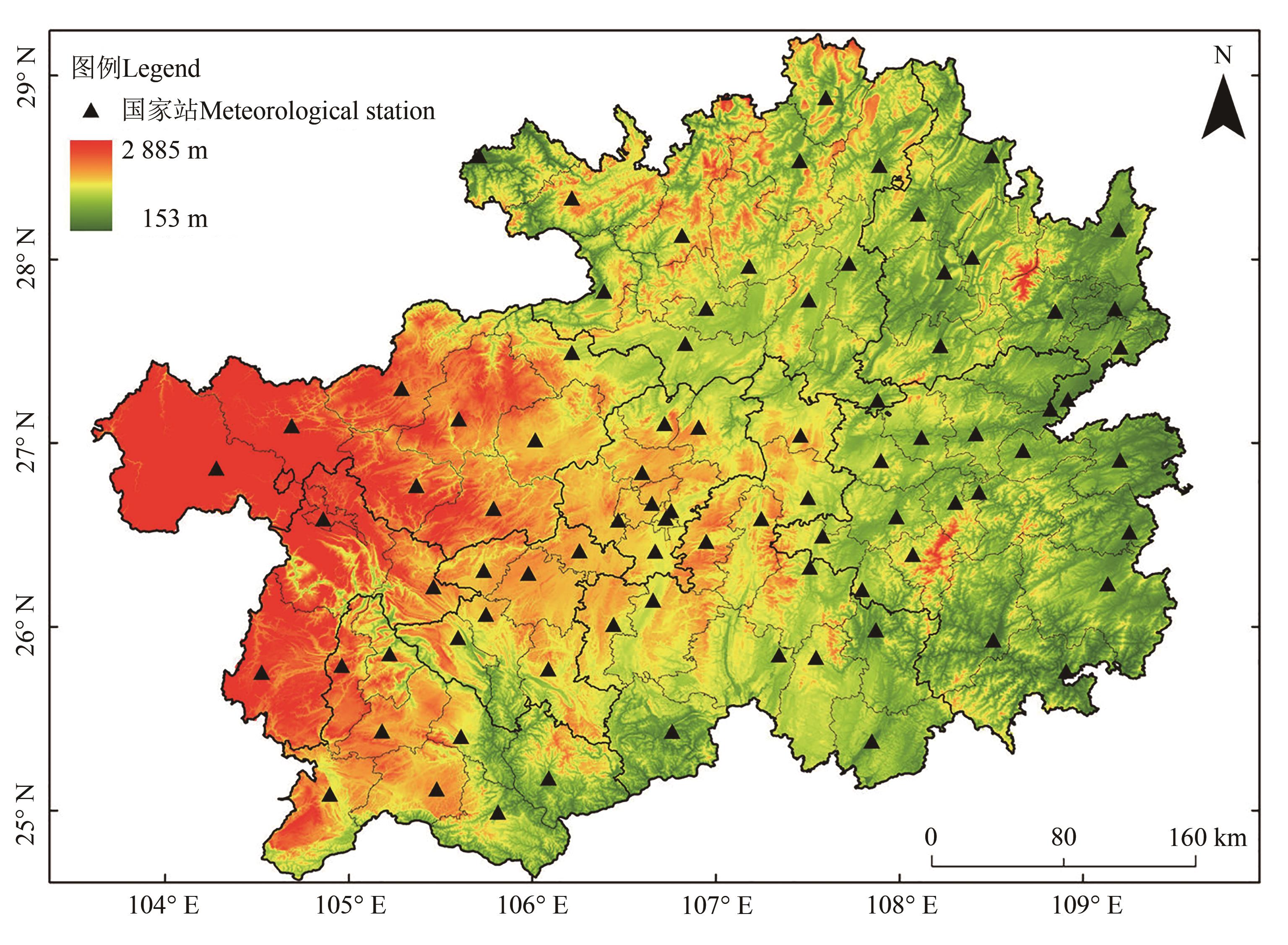
Fig. 1 Distribution of Meteorology stationsNote: The approval number of base map is GS(2017)3220.
| 灾害类型Disaster type | 等级 Grade | 标准 Standard |
|---|---|---|
| 霜冻Frost | 轻霜冻 Light frost | 0 ℃≤Tmin≤2 ℃ |
| 中霜冻 Medium frost | -2 ℃≤Tmin<0 ℃ | |
| 重霜冻 Heavy frost | Tmin<-2 ℃ | |
| 倒春寒Late spring cold | 轻级Light | 持续3~4 d Duration 3~4 d |
| 中级Medium | 持续5~6 d Duration 5~6 d | |
| 重级Heavy | 持续7~9 d Duration 7~9 d | |
| 特重Extra heavy | 持续≥10 d Duration≥10 d |
Table1 Classification standard of frost and late spring cold
| 灾害类型Disaster type | 等级 Grade | 标准 Standard |
|---|---|---|
| 霜冻Frost | 轻霜冻 Light frost | 0 ℃≤Tmin≤2 ℃ |
| 中霜冻 Medium frost | -2 ℃≤Tmin<0 ℃ | |
| 重霜冻 Heavy frost | Tmin<-2 ℃ | |
| 倒春寒Late spring cold | 轻级Light | 持续3~4 d Duration 3~4 d |
| 中级Medium | 持续5~6 d Duration 5~6 d | |
| 重级Heavy | 持续7~9 d Duration 7~9 d | |
| 特重Extra heavy | 持续≥10 d Duration≥10 d |
坡向 Slope aspect | 方位 Azimuth/(°) | 赋值Assignment | 坡向 Slope aspect | 方位 Azimuth/(°) | 赋值Assignment | 坡向 Slope aspect | 方位 Azimuth/(°) | 赋值Assignment |
|---|---|---|---|---|---|---|---|---|
南坡 South | [157.5,202.5) | 0 | 东坡 East | [67.5,112.5) | 0.5 | 西北坡Northwest | [292.5,337.5) | 0.5 |
东南坡 Southeast | [112.5,157.5) | 0 | 西坡 Western | [247.5,292.5) | 0.5 | 北坡 North | [0.0,22.5) | 1.0 |
西南坡 Southwest | [202.5,247.5) | 0 | 东北坡Northeast | [22.5,67.5) | 0.5 | 北坡 North | [337.5,360) | 1.0 |
Table 2 Standards of assigning value to the sensitivity index of slope aspect based on slope image element value
坡向 Slope aspect | 方位 Azimuth/(°) | 赋值Assignment | 坡向 Slope aspect | 方位 Azimuth/(°) | 赋值Assignment | 坡向 Slope aspect | 方位 Azimuth/(°) | 赋值Assignment |
|---|---|---|---|---|---|---|---|---|
南坡 South | [157.5,202.5) | 0 | 东坡 East | [67.5,112.5) | 0.5 | 西北坡Northwest | [292.5,337.5) | 0.5 |
东南坡 Southeast | [112.5,157.5) | 0 | 西坡 Western | [247.5,292.5) | 0.5 | 北坡 North | [0.0,22.5) | 1.0 |
西南坡 Southwest | [202.5,247.5) | 0 | 东北坡Northeast | [22.5,67.5) | 0.5 | 北坡 North | [337.5,360) | 1.0 |
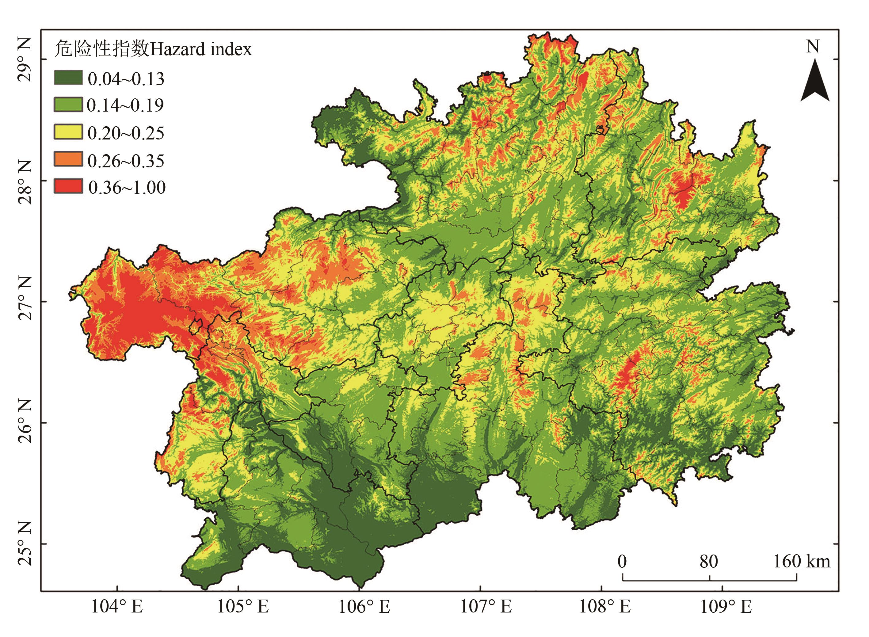
Fig. 2 Spatial distribution of hazard indexNote: The approval number of base map is GS(2017)3220.

Fig. 3 Spatial distribution of environment sensitiveness index to disastersNote: The approval number of base map is GS(2017)3220.
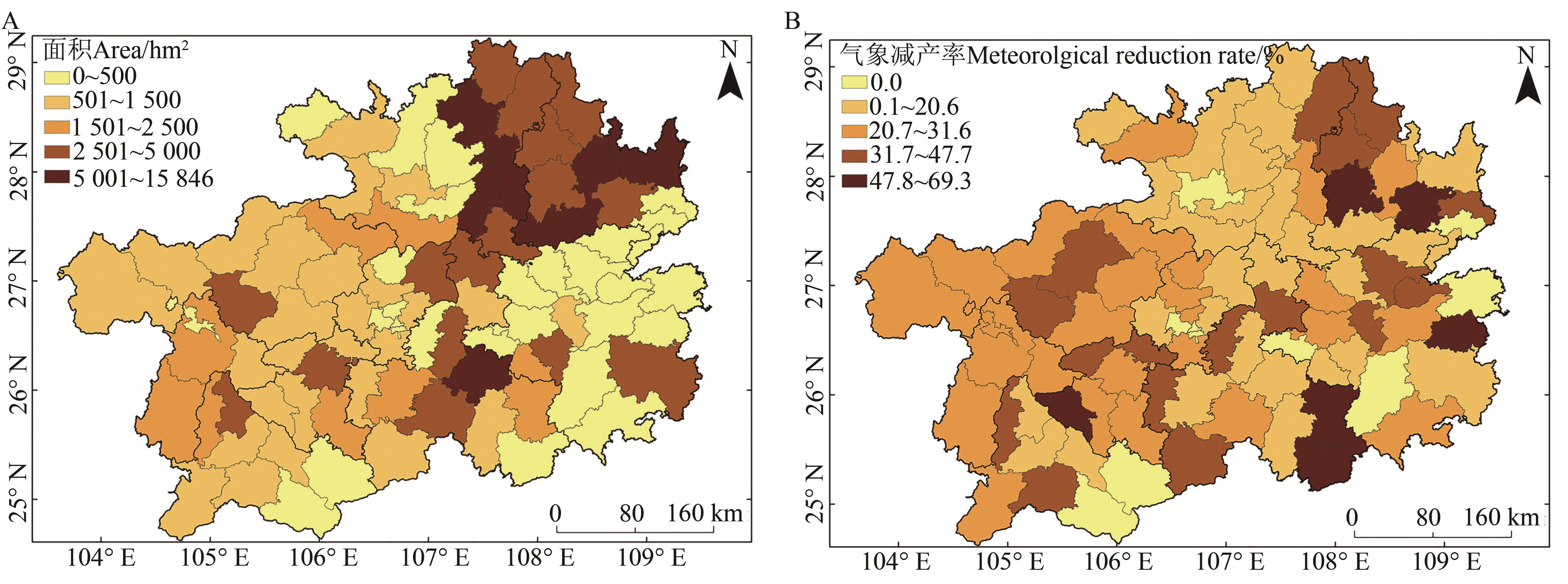
Fig. 4 Spatial distribution of tea planting area and meteorological yield reduction rateA: Tea garden area; B: Meteorological yield reduction rate. The approval number of base map is GS(2017)3220.

Fig. 5 Risk zonation oflow temperature damageNote: The approval number of base map is GS(2017)3220.
| 1 | 郭建平.农业气象灾害监测预测技术研究进展[J].应用气象学报,2016,27(5):620-630. |
| GUO J P. Research progress on agricultural meteorological disaster monitoring and forecasting [J]. J. Appl. Meteorol. Sci., 2016, 27(5):620-630. | |
| 2 | 王春乙,王石立,霍治国,等.近10年来中国主要农业气象灾害监测预警与评估技术研究进展[J].气象学报,2005,63(5):659-671. |
| WANG C Y, WANG S L, HUO Z G, et al.. Progress in research of agrometeorological disasters in china in recent decade [J]. Acta Meteorol. Sin., 2005, 63(5):659-671. | |
| 3 | 高文波,林正雨,王明田,等.1971—2020年西南茶区灌木型茶树晚霜冻害危险性时空演变特征[J].应用生态学报,2021,32(11):4029-4038. |
| GAO W B, LIN Z Y, WANG M T, et al.. Spatiotemporal evolution characteristics of the late frost damage risk to shrubby tea trees in tea region,southwest China from 1971 to 2020 [J]. J. Appl. Ecol., 2021, 32(11):4029-4038. | |
| 4 | 杨晓光,刘志娟,陈阜.全球气候变暖对中国种植制度可能影响I.气候变暖对中国种植制度北界和粮食产量可能影响的分析[J].中国农业科学,2010,43(2):329-336. |
| YANG X G, LIU Z J, CHEN F. The possible effects of global warming on cropping systems in China I. the possible effects of climate warming on northern limits of cropping systems and crop yields in China [J]. Sci. Agric. Sin., 2010, 43(2):329-336. | |
| 5 | 王春乙,张继权,霍治国,等.农业气象灾害风险评估研究进展与展望[J].气象学报, 2015,73(1):1-19. |
| WANG C Y, ZHANG J Q, HUO Z G, et al.. Prospects and progresses in the research of risk assessment of agro-meteorological disasters [J]. Acta Meteorol. Sin., 2015, 73(1):1-19. | |
| 6 | 郭凌曜,蒋元华,廖玉芳.油茶气象灾害普查和风险区划研究-以湖南为例[J].灾害学,2023,38(1):125-129. |
| GUO L Y, JIANG Y H, LIAO Y F. Camellia oleifera meteorological disaster census and risk zoning research: taking Hunan as an example [J]. J. Catastrophol., 2023, 38(1):125-129. | |
| 7 | 谢金花,黄琴琴,尚秉琛.安徽省油菜越冬期低温冻害时空分布特征及风险评估[J].气象科技,2023,51(2):287-294. |
| XIE J H, HUANG Q Q, SHANG B C. Time and space distribution characteristics and risk assessment of rape low temperature freezing damage in Anhui province [J]. Meteorol. Sci. Technol., 2023, 51(2):287-294. | |
| 8 | 汪宁,谢志清,高苹,等.江苏四类低温事件致灾因子与基于影响的低温风险时空分布对比研究[J].气象学报,2023,71(1):110-123. |
| WANG N, XIE Z Q, GAO P, et al.. Differences in spatiotemporal variation and risk zoning of four types of extreme cold events in Jiangsu province [J]. Acta Meteorol. Sin., 2023, 71(1):110-123. | |
| 9 | 刘瑞娜,陈鹏.安徽省茶叶春霜冻发生规律及风险分布[J].气象科技,2016,44(6):1060-1065. |
| LIU R N, CHEN P. Occurrence regularity of tea springy frost and its risk distribution in Anhui province [J]. Meteorol. Sci. Technol., 2016, 44(6):1060-1065. | |
| 10 | 姜燕敏,金志凤,李仁忠,等.浙南春茶早春霜冻的时空分布特征[J].气象科技,2016,44(6):1066-1070. |
| JIANG Y M, JIN Z F, LI R Z, et al.. Temporal and spatial distribution of early spring frost for spring tea in southern Zhejiang [J]. Meteor Sci. Technol., 2016, 44(6):1066-1070. | |
| 11 | 李时睿,朱兰娟,赵亮,等.安吉白茶精细化气象灾害风险分析与区划[J].生态学杂志,2024, 43(3):904-912. |
| LI S R, ZHU L J, ZHAO L, et al.. Refined meteorological risk analysis and zoning of Anji white tea [J]. Chin. J. Ecol., 2024, 43(3):904-912. | |
| 12 | 范辽生,金志凤,王培娟,等.物候模型支持下的杭州市春茶霜冻害时空变化及风险区划[J].生态学杂志,2021,40(3):919-928. |
| FAN L S, JIN Z F, WANG P J, et al.. Spatiotemporal variation and risk regionalization of frost damage of spring tea in Hangzhou city based on the phenological model [J]. Chin. J. Ecol., 2021, 40(3):919-928. | |
| 13 | 李柏贞,谢佳杏,孔萍,等.江南茶叶农业气象灾害风险区划[J].干旱气象,2015,33(6):1017-1023. |
| LI B Z, XIE J X, KONG P, et al.. Comprehensive risk division of agro-meteorological disaster for tea in southern Yangtze River [J]. J. Arid Meteorol., 2015, 33(6):1017-1023. | |
| 14 | 蔡仕博,江晓东,李时睿,等.气候变化背景下宁波市茶叶早春霜冻灾害风险评估[J].气象科学,2023,51(2):254-261. |
| CAI S B, JIANG X D, LI S R, et al.. Estimation of early pring frost damage for tea plants in Ningbo under the background of climate change [J]. J. Meteorol. Sci., 2023, 51(2):254-261. | |
| 15 | 贵州省统计局.贵州省统计年鉴[M].北京:中国统计出版社,2021:1-153. |
| 16 | 杜尧东,李春梅,毛慧琴.广东省香蕉与荔枝寒害致灾因子和综合气候指标研究[J].生态学杂志,2006,25(2):225-230. |
| DU Y D, LI C M, MAO H Q. Disaster-inducing factors and integrated climatic index for banana and litchi chilling injuries in Guangdong province [J]. Chin. J. Ecol., 2006, 25(2):225-230 | |
| 17 | 王华,杜尧东,张羽,等.广东晚稻寒露风保险风险区划[J].气象与环境科学,2018,41(4):98-102. |
| WANG H, DU Y D, ZHANG Y, et al.. Insurance risk zoning of late rice cold dew wind in Guangdong [J]. Meteorol. Environ. Sci., 2018, 41(4):98-102. | |
| 18 | 刘瑞娜,陈金华,陈曦,等.安徽茶树春霜冻害的风险评估[J].中国农业气象,2021,42(10):870-879. |
| LIU R N, CHEN J H, CHEN X, et al.. Risk assessment of spring frost damage to tea plant in Anhui province [J]. Chin. J. Agrometeorol., 2021, 42(10):870-879. | |
| 19 | 信桂新,杨朝现,杨庆媛,等.用熵权法和改进 TOPSIS模型评价高标准基本农田建设后效应[J].农业工程学报,2017,33(1):238-249. |
| XIN G X, YANG C X, YANG Q Y, et al.. Post-evaluation of well-facilitied capital farmland construction based on entropy weight method and improved TOPSIS model [J]. Trans. Chin. Soc. Agric. Eng., 2017, 33(1):238-249. | |
| 20 | 葛道阔,曹宏鑫,张文宇,等.4种水稻气象产量分离方法的对比研究[J].江西农业学报,2020,32(12):1-6. |
| GE D K, CAO H X, ZHANG W Y, et al.. Comparative study on four methods for separating rice meteorological yield [J]. Acta Agric. Jiangxi, 2020, 32(12):1-6. | |
| 21 | 中国气象局. 茶树霜冻害等级: [S].北京:中国标准出版社,2017. |
| 22 | 王培娟,唐俊贤,金志凤,等.中国茶树春霜冻害研究进展[J].应用气象学报,2021,32(2):129-145. |
| WANG P J, TANG J X, JIN Z F, et al.. Review on spring frost disaster for tea plant in China [J]. J. Appl. Meteorol. Sci., 2021, 32(2):129-145. | |
| 23 | 许炳南,张弼州.贵州春旱、夏旱、倒春寒、秋风的规律成因及长期预报研究[M].北京:气象出版社,1997:6. |
| 24 | 李蔼恂,柳艳香,郜婧婧.高速公路低能见度危险性评价方法比较[J].气象科技进展,2017,7(6):11-17. |
| LI A X, LIU Y X, GAO J J. Comparison among three assessment methods for low visibility hazards on highway [J]. Adv. Meteorol. Sci. Technol., 2017, 7(6):11-17. | |
| 25 | 王洁,张中杰,曲晓黎,等.基于层次分析法的朔黄铁路暴雨灾害风险评估[J].气象科技,2022,50(6):870-877. |
| WANG J, ZHANG Z J, QU X L, et al.. Risk zoning of rainstorm disaster along shuohuang railway based on meteorological geography method [J]. Meteorol. Sci. Technol., 2022, 50(6):870-877. | |
| 26 | 张宏,温永宁,刘爱利.地理信息系统算法基础[M].北京:科学出版社,2006:159-161. |
| 27 | 孙朝锋,林雯,黄川容,等.华南芒果种植区寒冻害危险性区划与评估[J].中国农业气象,2022,43(7):563-575. |
| SUN C F, LIN W, HUANG C R, et al.. GIS-based risk zoning and assessment of mongo cold and freezing injury in south China [J]. Chin. J. Agrometeorol., 2022, 43(7):563-575. | |
| 28 | 王丽媛,于飞.农业气象灾害风险分析及区划研究进展[J].贵州农业科学,2011,39(11):84-88. |
| WANG L Y, YU F. Advances in risk analysis and zonging on argo-meteorological disasters [J].Guizhou Agric. Sci., 2011, 39(11):84-88. | |
| 29 | 黄川容,陈家金,孙朝锋,等.福建省茶叶寒冻害气象指数保险分级设计[J].中国生态农业学报,2021,29(12):2074-2083. |
| HUANG C R, CHEN J J, SUN C F, et al.. Classification design of the meteorological index insurance for cold-frost damage on tea in Fujian province [J]. Chin. J. Eco-Agric., 2021, 29(12): 2074-2083 | |
| 30 | 汪春辉,陈治杰,陈家金,等.茶叶寒冻害天气指数保险设计[J].气象科技,2020,48(1):141-146. |
| WANG C H, CHEN Z J, CHEN J J, et al.. Design of index-based weather insurance for tea cold and freezing damage [J]. Meteorol. Sci. Technol., 2020, 48(1):141-146. |
| [1] | Suilin ZHANG, Yang LI, Yan LI, Yunqi ZHANG, Jianxun QI, Zhixia HOU. Research Progress on Harmful Characteristics and Mechanism of Walnut Late Frost [J]. Journal of Agricultural Science and Technology, 2024, 26(4): 18-26. |
| [2] | SUN Yan, PU Wenxuan, WU Changzheng, HUANG Pingjun, SUN Mingxue, SONG Dean, LIU Laihua. Research Progress on Plant Growth, Development and Its Molecular Mechanism in Response to Sub-optimal Low Temperature [J]. Journal of Agricultural Science and Technology, 2021, 23(5): 18-26. |
| [3] | ZHAO Hu1,2, WANG Haibin2,3*, CHEN Xiaoting2,3, WANG Yuhua2, ZHANG Huabin2, DING Li2, KONG Xianghai2, SHI Guiying1*. Analysis of Nitrogen Composition and its Absorption and Utilization Efficiency in Rhizosphere Soil of Tea Tree [J]. Journal of Agricultural Science and Technology, 2020, 22(7): 148-153. |
| [4] | LI Yangzheng, LI Lan, WANG Xiaoer, CAO Xi, PENG Jianyu, XUE Xiaohui, YOU Ping. Effects of Environmetal Factors Such as Surface Cover on Soil Organic Nitrogen Composition in Northwestern District of Guizhou [J]. Journal of Agricultural Science and Technology, 2020, 22(10): 157-166. |
| [5] | WANG Haibin1,2, ZHANG Qingxu1, CHEN Xiaoting1, MA Xiaomao1, ZHAO Hu1,YE Jianghua2,3, KONG Xianghai1. Effect of Animal Manure on Soil Acidity and Microbe of Tea Tree Rhizosphere [J]. Journal of Agricultural Science and Technology, 2017, 19(5): 115-122. |
| [6] | ZHOU Ziwei1,2§, CHANG Xiaojun1,2§, YOU Fangning1,2, . Analysis of Molecular Evolution and Codon Bias of Lipoxygenase (LOX) Gene Family in Tea Tree [J]. Journal of Agricultural Science and Technology, 2017, 19(12): 43-51. |
| [7] | OU Zhen-gui, LI Qing, LUO Ya-hong, TIAN Da-qing, ZHOU Zheng-bang. Studies on Regional Test of Newly Introduced Cassava Variety in Guizhou [J]. , 2012, 14(1): 136-141. |
| Viewed | ||||||
|
Full text |
|
|||||
|
Abstract |
|
|||||
 京公网安备11010802021197号