


Journal of Agricultural Science and Technology ›› 2024, Vol. 26 ›› Issue (2): 109-119.DOI: 10.13304/j.nykjdb.2022.0703
• INTELLIGENT AGRICULTURE & AGRICULTURAL MACHINERY • Previous Articles
Hong ZHANG1,2( ), Weiguo LI1,2(), Xiaodong ZHANG2, Bihui LU1, Chengcheng ZHANG1, Wei LI3, Tinghuai MA4
Received:2022-08-23
Accepted:2022-10-24
Online:2024-02-15
Published:2024-02-04
Contact:
Weiguo LI
张宏1,2(), 李卫国1,2(), 张晓东2, 卢必慧1, 张琤琤1, 李伟3, 马廷淮4
通讯作者:
李卫国
作者简介:张宏 E-mail:823631981@qq.com;
基金资助:CLC Number:
Hong ZHANG, Weiguo LI, Xiaodong ZHANG, Bihui LU, Chengcheng ZHANG, Wei LI, Tinghuai MA. Extraction of Winter Wheat Planting Area Based on Fusion Features of HJ-1 and GF-1 Image[J]. Journal of Agricultural Science and Technology, 2024, 26(2): 109-119.
张宏, 李卫国, 张晓东, 卢必慧, 张琤琤, 李伟, 马廷淮. 基于HJ-1星和GF-1号影像融合特征提取冬小麦种植面积[J]. 中国农业科技导报, 2024, 26(2): 109-119.
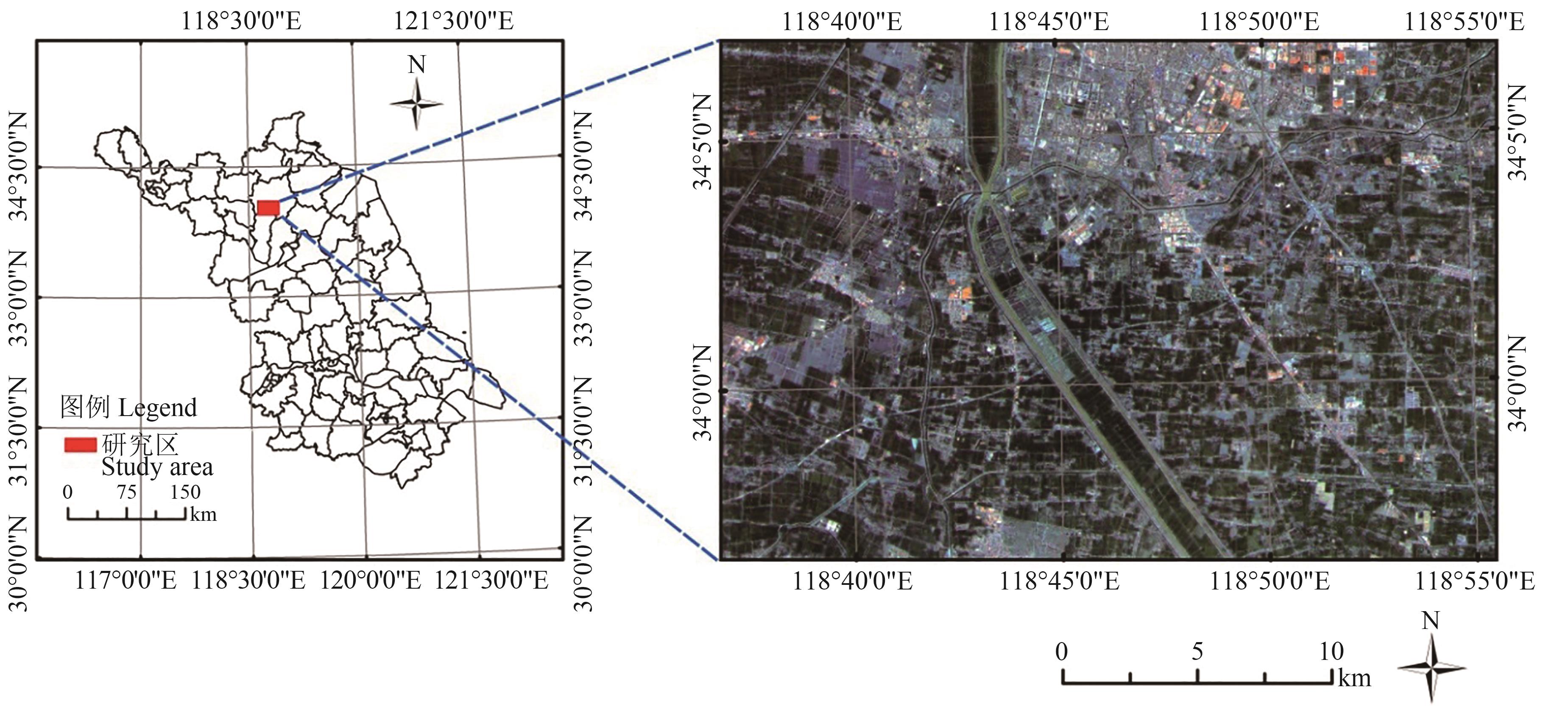
Fig. 1 Study area of winter wheat planting area extraction
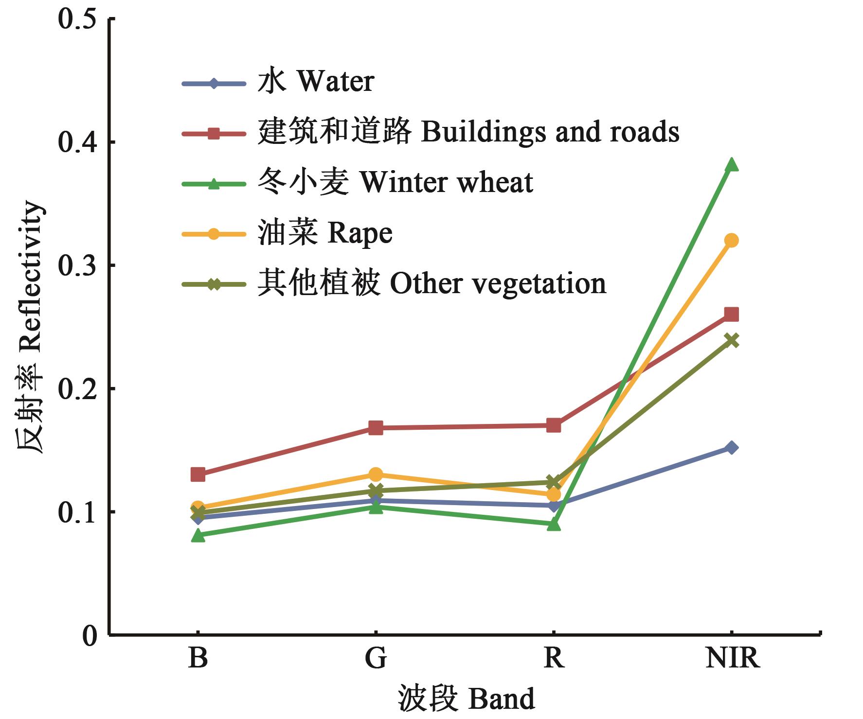
Fig. 2 The reflectivity of main objects in HJ satellite image
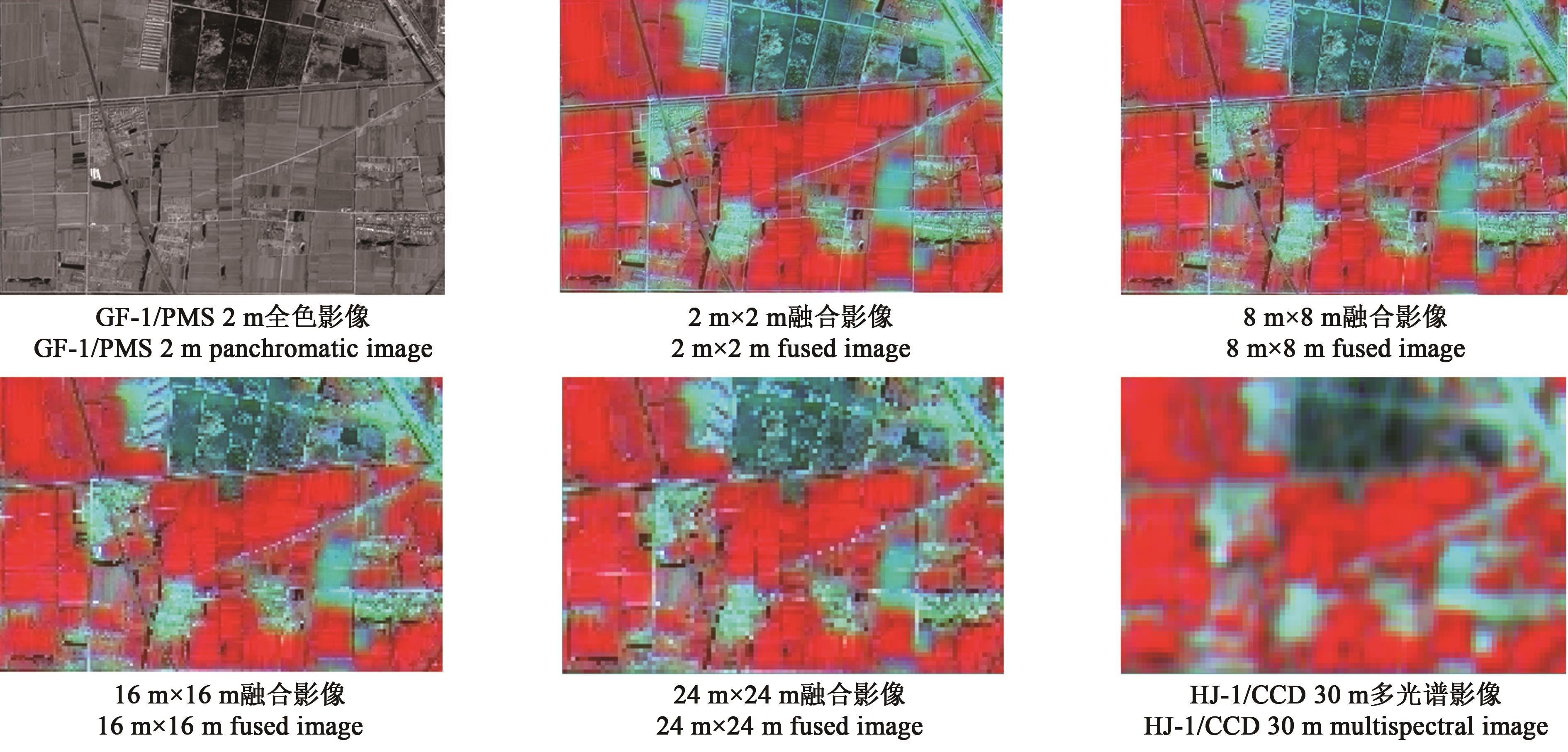
Fig. 3 Comparison between fused images at different scales and original images of local area
融合尺度 Scale of fusion | 均值 Mean value | 标准差 Standard deviation | 平均梯度 Average gradient | 相关系数 Correlation coefficient |
|---|---|---|---|---|
| 2 m×2 m | 160.98±8.21 a | 78.60±4.09 a | 1.81±0.06 c | 0.95±0.06 a |
| 8 m×8 m | 161.01±5.31 a | 82.93±3.73 a | 2.97±0.12 c | 0.96±0.05 a |
| 16 m×16 m | 161.15±6.45 a | 83.01±4.48 a | 4.55±0.23 c | 0.97±0.06 a |
| 24 m×24 m | 165.03±9.08 a | 83.59±5.02 a | 6.13±0.36 c | 0.85±0.03 b |
Table 1 Evaluation indices of different scale fusion images of local area
融合尺度 Scale of fusion | 均值 Mean value | 标准差 Standard deviation | 平均梯度 Average gradient | 相关系数 Correlation coefficient |
|---|---|---|---|---|
| 2 m×2 m | 160.98±8.21 a | 78.60±4.09 a | 1.81±0.06 c | 0.95±0.06 a |
| 8 m×8 m | 161.01±5.31 a | 82.93±3.73 a | 2.97±0.12 c | 0.96±0.05 a |
| 16 m×16 m | 161.15±6.45 a | 83.01±4.48 a | 4.55±0.23 c | 0.97±0.06 a |
| 24 m×24 m | 165.03±9.08 a | 83.59±5.02 a | 6.13±0.36 c | 0.85±0.03 b |
| 植被类型 Vegetation type | 同质性 Homogeneity | 熵 Entropy | 角二阶距 Angular second moment | 对比度 Contrast |
|---|---|---|---|---|
| 冬小麦 Winter wheat | 0.80 | 1.39 | 0.31 | 0.66 |
| 油菜 Rape | 0.72 | 1.12 | 0.32 | 0.70 |
| 其他植被 Other vegetation | 0.60 | 1.27 | 0.21 | 1.33 |
Table 2 Statistics of texture characteristics of 3 vegetation types in FI16m
| 植被类型 Vegetation type | 同质性 Homogeneity | 熵 Entropy | 角二阶距 Angular second moment | 对比度 Contrast |
|---|---|---|---|---|
| 冬小麦 Winter wheat | 0.80 | 1.39 | 0.31 | 0.66 |
| 油菜 Rape | 0.72 | 1.12 | 0.32 | 0.70 |
| 其他植被 Other vegetation | 0.60 | 1.27 | 0.21 | 1.33 |
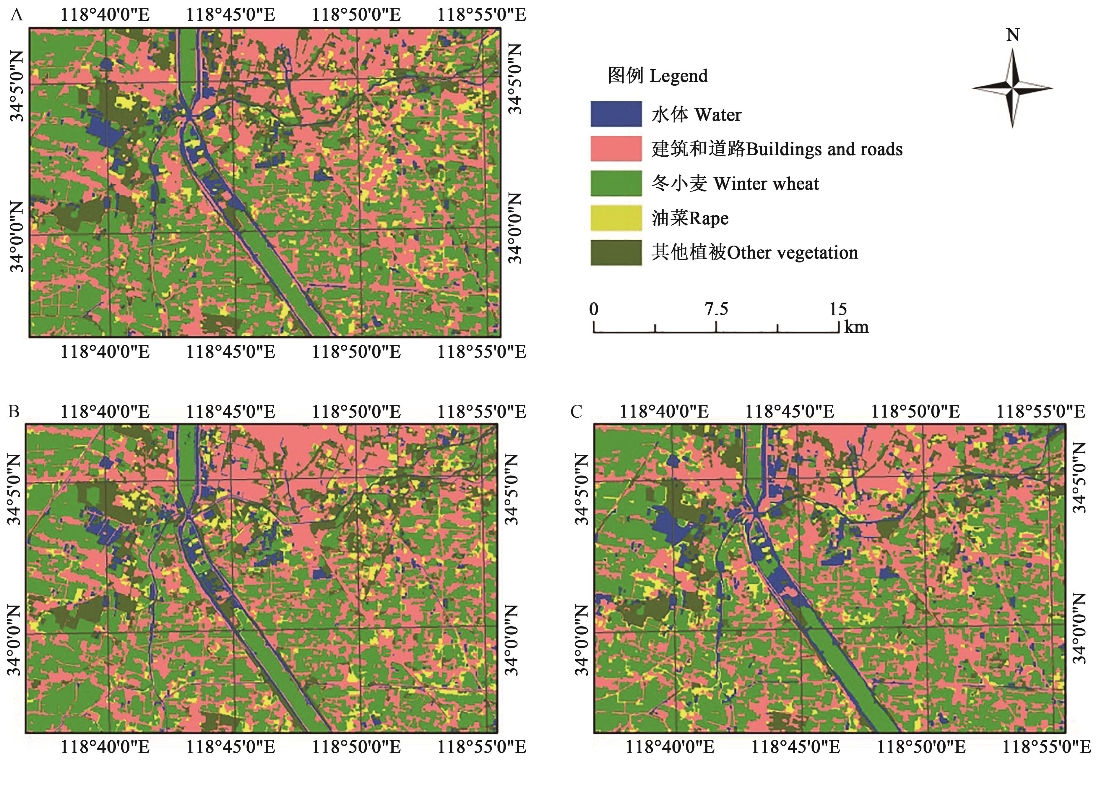
Fig. 4 Object-oriented classification results for different combinations of training samples and imagesA: Combination 1; B: Combination 2; C: Combination 3
分类组合 Classification combination | 训练样本 Training sample | 影像 Image | 冬小麦 Winter wheat/hm2 | 油菜 Rape/hm2 | 其他植被 Other vegetation/hm2 |
|---|---|---|---|---|---|
| 组合一 Combination 1 | SFI | RI16m | 22 783 | 2 995 | 7 386 |
| 组合二 Combination 2 | SFI | FI16m | 21 117 | 3 069 | 7 239 |
| 组合三 Combination 3 | SRI | RI16m | 23 148 | 3 360 | 5 835 |
Table 3 Vegetation area extracted from different classification combination of training samples and images
分类组合 Classification combination | 训练样本 Training sample | 影像 Image | 冬小麦 Winter wheat/hm2 | 油菜 Rape/hm2 | 其他植被 Other vegetation/hm2 |
|---|---|---|---|---|---|
| 组合一 Combination 1 | SFI | RI16m | 22 783 | 2 995 | 7 386 |
| 组合二 Combination 2 | SFI | FI16m | 21 117 | 3 069 | 7 239 |
| 组合三 Combination 3 | SRI | RI16m | 23 148 | 3 360 | 5 835 |
分类组合 Classification combinations | 训练样本 Training sample | 影像 Image | 精度 Accuracy | 水体 Water/% | 建筑和道路 Buildings and roads/% | 冬小麦 Winter wheat/ % | 油菜 Rape/ % | 其他植被 Other vegetation/ % | 总体精度 Overall Accuracy/ % | Kappa系数 Kappa Coefficient |
|---|---|---|---|---|---|---|---|---|---|---|
组合一 Combination 1 | SFI | RI16m | 生产者精度 Producer accuracy | 90.00 | 92.00 | 97.78 | 85.00 | 91.43 | 92.22 | 0.90 |
用户精度 User accuracy | 96.43 | 93.88 | 91.67 | 89.47 | 88.89 | |||||
组合二 Combination 2 | SFI | FI16m | 生产者精度 Producer accuracy | 93.33 | 96.00 | 97.78 | 90.00 | 91.43 | 94.44 | 0.93 |
用户精度 User accuracy | 100 | 90.57 | 100 | 85.71 | 94.12 | |||||
组合三 Combination 3 | SRI | RI16m | 生产者精度 Producer accuracy | 83.33 | 86.00 | 93.33 | 70.00 | 80.00 | 84.44 | 0.80 |
用户精度 User accuracy | 83.33 | 82.70 | 91.30 | 73.68 | 84.85 |
Table 4 Classification accuracy evaluation of different classification combinations of training samples and images
分类组合 Classification combinations | 训练样本 Training sample | 影像 Image | 精度 Accuracy | 水体 Water/% | 建筑和道路 Buildings and roads/% | 冬小麦 Winter wheat/ % | 油菜 Rape/ % | 其他植被 Other vegetation/ % | 总体精度 Overall Accuracy/ % | Kappa系数 Kappa Coefficient |
|---|---|---|---|---|---|---|---|---|---|---|
组合一 Combination 1 | SFI | RI16m | 生产者精度 Producer accuracy | 90.00 | 92.00 | 97.78 | 85.00 | 91.43 | 92.22 | 0.90 |
用户精度 User accuracy | 96.43 | 93.88 | 91.67 | 89.47 | 88.89 | |||||
组合二 Combination 2 | SFI | FI16m | 生产者精度 Producer accuracy | 93.33 | 96.00 | 97.78 | 90.00 | 91.43 | 94.44 | 0.93 |
用户精度 User accuracy | 100 | 90.57 | 100 | 85.71 | 94.12 | |||||
组合三 Combination 3 | SRI | RI16m | 生产者精度 Producer accuracy | 83.33 | 86.00 | 93.33 | 70.00 | 80.00 | 84.44 | 0.80 |
用户精度 User accuracy | 83.33 | 82.70 | 91.30 | 73.68 | 84.85 |
| 1 | 李卫国,王纪华,赵春江,等.基于遥感信息和产量形成过程的小麦估产模型[J].麦类作物学报, 2007(5): 904-907. |
| LI W G, WANG J H, ZHAO C J, et al.. A model of estimating winter wheat yield based on tm image and yield formation [J]. J. Triticeae Crops, 2007(5):904-907. | |
| 2 | LI W, LIU Y, CHEN H, et al.. Estimation model of winter wheat disease based on meteorological factors and spectral information [J/OL]. Food Prod. Process. Nutr., 2020, 2:5 [2022-09-01]. . |
| 3 | LI X, MENG Q, GU X, et al.. A hybrid method combining pixel-based and object-oriented methods and its application in Hungary using Chinese HJ-1 satellite images [J]. Int. J. Remote Sens., 2013, 34(13-14): 4655-4668. |
| 4 | 李卫国,顾晓鹤,葛广秀,等.县域冬小麦病害遥感监测信息系统研制[J].江苏农业学报,2019, 35(2): 302-306. |
| LI W G, GU X H, GE G X, et al.. Development of remote sensing monitoring information system for county scale winter wheat diseases [J]. Jiangsu J. Agric. Sci., 2019, 35(2): 302-306. | |
| 5 | ZHOU Q, YU Q, LIU J, et al.. Perspective of Chinese GF-1 high-resolution satellite data in agricultural remote sensing monitoring [J]. J. Integr. Agric., 2017, 16(2): 242-251. |
| 6 | 林子晶,李卫国,申双和,等.HJ星和GF1号数据在水稻种植面积提取中的应用[J].江苏农业学报, 2016, 32(1): 111-117. |
| LI Z J, LI W G, SHEN S H, et al.. Application of HJ and GF1 image data to extract rice planting area [J]. Jiangsu J. Agric. Sci., 2016, 32(1): 111-117. | |
| 7 | 金正婷,李卫国,景元书.基于影像融合的冬小麦种植面积提取适宜尺度研究[J].江苏农业学报, 2015, 31(6): 1312-1317. |
| JIN Z T, LI W G, JING Y S. Appropriate extraction scale of winter wheat planting area based on image fusion [J]. Jiangsu J. Agric. Sci., 2015, 31(6): 1312-1317. | |
| 8 | 李卫国,陈华,金正婷,等.基于适宜尺度选择的冬小麦赤霉病遥感监测[J].麦类作物学报, 2018, 38(11): 1374-1380. |
| LI W G, CHEN H, JIN Z T, et al.. Remote sensing monitoring of winter wheat scab based on suitable scale selection [J]. J. Triticeae Crops, 2018, 38(11): 1374-1380. | |
| 9 | 李雪欣,马保东,张嵩,等.融合多光谱与SAR影像的地物分类研究[J].测绘与空间地理信息, 2019, 42(12): 55-58. |
| LI X X, MA B D, ZHANG S, et al.. Study on classification of ground objects with multispectral and SAR images [J]. Map. Spa. Geogr. Inform., 2019, 42(12): 55-58. | |
| 10 | SEO D K, KIM Y H, EO Y D, et al.. Fusion of SAR and multispectral images using random forest regression for change detection [J]. ISPRS Int. J. Geo-Inf., 2018, 7(10): 401. |
| 11 | 李双成,郑度.人工神经网络模型在地学研究中的应用进展[J].地球科学进展, 2003(1): 68-76. |
| LI S C, ZHENG D. Applications of artificial neural networks to geosciences: review and prospect [J]. Adv. Earth Sci., 2003(1): 68-76. | |
| 12 | 李卫国,李正金,王纪华,等.基于ISODATA的冬小麦籽粒蛋白质含量遥感分级监测[J].江苏农业学报,2009, 25(6): 1247-1251. |
| LI W G, LI Z J, WANG J H, et al.. Classification monitoring of grain protein contents of winter wheat by TM image based on ISODATA [J]. Jiangsu J. Agric. Sci., 2009, 25(6): 1247-1251. | |
| 13 | 李楠,朱秀芳,潘耀忠,等.人工蜂群算法优化的SVM遥感影像分类[J].遥感学报,2018, 22(4): 559-569. |
| LI N, ZHU X F, PAN Y Z, et al.. Optimized SVM based on artificial bee colony algorithm for remote sensing image classification [J]. J. Remote Sens., 2018, 22(4): 559-569 | |
| 14 | IZQUIERDO-VERDIGUIER E, LAPARRA V, GOMEZ-CHOVA L, et al.. Encoding invariances in remote sensing image classification with SVM [J]. IEEE Geosic. Remote Sens., 2013, 10(5): 981-985. |
| 15 | 周春艳,王萍,张振勇,等.基于面向对象信息提取技术的城市用地分类[J].遥感技术与应用, 2008(1): 31-35, 123. |
| ZHOU C Y, WANG P, ZHANG Z Y, et al.. Classification of urban land based on object-oriented information extraction technology [J]. Remote Sens. Technol. Appl., 2008(1): 31-35, 123. | |
| 16 | 莫利江,曹宇,胡远满,等.面向对象的湿地景观遥感分类—以杭州湾南岸地区为例[J].湿地科学,2012,10(2):206-213. |
| MO L J, CAO Y, HU Y M, et al.. Object-oriented classification for satellite remote sensing of wetlands: a case study in southern Hangzhou bay area [J]. Wetland Sci.,2012,10(2):206-213. | |
| 17 | 李正金,李卫国,申双和.基于优化ISODATA法的冬小麦长势分级监测[J].江苏农业科学, 2009(2): 301-302. |
| LI Z J, LI W G, SHEN S H. A classification of wheat yield by remote-monitoring based on optimization ISODATA [J]. Jiangsu J. Agric. Sci., 2009(2):301-302. | |
| 18 | SHACKELFORD A K, DAVIS C H. A combined fuzzy pixel-based and object-based approach for classification of high-resolution multispectral data over urban areas [J]. IEEE Trans. Geosci. Remote, 2003, 41(10): 2354-2363. |
| 19 | 宋明辉.基于高分二号数据的面向对象城市土地利用分类研究[J].遥感技术与应用, 2019, 34(3): 547-552, 629. |
| SONG M H. Object-oriented urban land classification with GF-2 remote sensing image [J]. Remote Sens. Technol. Appl., 2019, 34(3) : 547-553, 629. | |
| 20 | LIU Y, LI M, MAO L, et al.. Review of remotely sensed imagery classification patterns based on object-oriented image analysis [J]. Chin. Geogr. Sci., 2006(3): 282-288. |
| 21 | CUI W, ZHENG Z, ZHOU Q, et al.. Application of a parallel spectral-spatial convolution neural network in object-oriented remote sensing land use classification [J]. Remote Sens. Lett., 2018, 9(4-6): 334-342. |
| 22 | 张颖,何贞铭,吴贞江.基于多源遥感影像的农作物分类提取[J].山东农业大学学报(自然科学版), 2021, 52(4): 615-618. |
| ZHANG Y, HE Z M, WU Z J. Crop classification and extraction based on multi-source remote sensing image [J]. J. Shandong Agric. Univ. (Nat. Sci.), 2021, 52(4): 615-618. | |
| 23 | ZHOU Z, HUANG J, WANG J, et al.. Object-oriented classification of sugarcane using time-series middle-resolution remote sensing data based on AdaBoost [J]. PLoS One, 2015, 10: e0142069 [2022-09-01]. . |
| 24 | 高雨,胡召玲,樊茹.高分辨率影像融合算法对滨海湿地土地利用分类精度的影响[J].测绘通报, 2022(1): 116-120. |
| GAO Y, HU Z L, FAN R. Effect of high-resolution image fusion algorithm on the classification precision of land utilization in coastal wetland [J]. Bull. Surv. Map., 2022(1):116-120. | |
| 25 | 王芳,杨武年,王建,等.国产高分卫星像素级影像融合及其质量评价[J].测绘科学, 2021, 46(8): 73-80. |
| WANG F, YANG W N, WANG J, et al.. Chinese high-resolution satellite pixel level image fusion and its quality evaluation [J].Sci. Surv. Map., 2021, 46(8):73-80. | |
| 26 | WANG Z, NIE C, WANG H, et al.. Detection and analysis of degree of maize lodging using UAV-RGB image multi-feature factors and various classification methods [J]. ISPRS Int. J. Geo-Inf., 2021, 10(5):309. |
| 27 | JIN B, YE P, ZHANG X, et al.. Object-Oriented method combined with deep convolutional neural networks for land-use-type classification of remote sensing images [J]. J. Ind. Soc. Remote, 2019, 47(6): 951-965. |
| 28 | 李卫国,蒋楠.基于面向对象分类的冬小麦种植面积提取[J].麦类作物学报,2012,32(4):701-705. |
| LI W G, JIANG N. Extraction of winter wheat planting area by object-oriented classification method [J]. J. Triticeae Crops, 2012,32(4):701-705. | |
| 29 | 赵搏华,王秀茹,阎世煜,等.面向对象分类方法在水土保持措施提取中的应用[J].中国水土保持科学, 2022, 20(1):122-127. |
| ZHAO B H, WANG X R, YAN S Y, et al.. Application of object-oriented classification method in the extraction of soil and water conservation measures [J]. Sci. Soil Water Conserv., 2022, 20(1):122-127. | |
| 30 | 李前景,刘珺,米晓飞,等.面向对象与卷积神经网络模型的GF-6 WFV影像作物分类[J].遥感学报,2021, 25(2): 549-558. |
| LI Q J, LIU J, MI X F, et al.. Object-oriented crop classification for GF-6 WFV remote sensing images based on convolutional neural network [J]. J. Remote Sens., 2021, 25(2): 549-558. | |
| 31 | 李卫国,黄文江,董莹莹,等.基于温湿度与遥感植被指数的冬小麦赤霉病估测[J].农业工程学报, 2017, 33(23): 203-210. |
| LI W G, HUANG W J, DONG Y Y, et al.. Estimation on winter wheat scab based on combination of temperature, humidity and remote sensing vegetation index [J]. Trans. Chin. Soc. Agric. Eng., 2017, 33(23):203-210. | |
| 32 | GU X H, LI W G, WANG L. Understanding vegetation changes in northern China and Mongolia with change vector analysis [J]. Springer Plus, 2016, 5:1780-1793. |
| 33 | 裴欢,孙天娇,王晓妍.基于Landsat 8 OLI影像纹理特征的面向对象土地利用/覆盖分类[J].农业工程学报, 2018, 34(2): 248-255. |
| PEI H, SUN T J, WANG X Y. Object-oriented land use/cover classification based on texture features of Landsat 8 OLI image [J]. Trans. Chin. Soc. Agric. Eng., 2018, 34(2): 248-255. | |
| 34 | REGNIERS O, BOMBRUN L, LAFON V, et al.. Supervised classification of very high resolution optical images using wavelet-based textural features [J]. IEEE Trans. Geosci. Remote, 2016, 54(6): 3722-3735. |
| 35 | 闻馨,贾明明,李晓燕,等.基于无人机可见光影像的红树林冠层群落识别[J].森林与环境学报, 2020, 40(5): 486-496. |
| WEN X, JIA M M, LI X Y, et al.. Identification of mangrove canopy species based on visible unmanned aerial vehicle images [J]. J. Fore Environ., 2020, 40(5):486-496. | |
| 36 | 王宇航,范文义,刘超逸.基于面向对象的QUICKBIRD数据和SAR数据融合的地物分类[J].东北林业大学学报,2016, 44(9): 44-49. |
| WANG Y H, FAN W Y, LIU C Y. An object-based fusion of QUICKBIRD data and RADARSAT SAR data for classification analysis [J]. J. Northeast Fore. Univ., 2016, 44(9): 44-49. | |
| 37 | 吴忠强,毛志华,王正,等.基于多源影像融合去云的水深遥感反演研究—以哨兵-2A和资源三号为例[J].测绘与空间地理信息, 2019, 42(11): 12-16. |
| WU Z Q, MAO Z H, WANG Z, et al.. Shallow water depth retrieval from multi-scale multi-spectral satellite data: take Sentinel-2A and Resource 3 as an example [J]. Map. Spa. Geogr. Inform., 2019, 42(11): 12-16. | |
| 38 | ZHAO F C, WU X M, WANG S. Object-oriented vegetation classification method based on UAV and satellite image fusion [J]. Procedia Comput. Sci., 2020, 174:609-615. |
| 39 | 聂倩,七珂珂,赵艳福.融入超像素分割的高分辨率影像面向对象分类[J].测绘通报, 2021(6): 44-49. |
| NIE Q, QI K K, ZHAO Y F. Object-oriented classification of high resolution image combining super-pixel segmentation [J]. Bull. Surv. Map., 2021(6):44-49. | |
| 40 | 万剑华,臧金霞,刘善伟.顾及极化特征的SAR与光学影像融合与分类[J].光学学报, 2017, 37(6): 292-301. |
| WAN J H, ZANG J X, LIU S W. Fusion and classification of SAR and optical image with consideration of polarization characteristics [J]. Acta Optica Sin., 2017, 37(6): 292-301. |
| [1] | Qian GUO, Jiahao WEI, Jian ZHANG, Zhangxi YE, Houxi ZHANG, Zhengqing LAI, Hui DENG. Vegetable Recognition Based on Unmanned Aerial Vehicle (UAV) Multispectral Imagery and Random Forest Algorithm [J]. Journal of Agricultural Science and Technology, 2023, 25(2): 99-110. |
| [2] | Lingwen HU, Zhongfa ZHOU, Linjiang YIN, Meng ZHU, Denghong HUANG. Rape Identification at Seedling Stage Based on UAV RGB Image [J]. Journal of Agricultural Science and Technology, 2022, 24(9): 116-128. |
| [3] | Yinyan GAO, Yi SUN, Baochun LI. Estimating of Wheat Ears Number in Field Based on RGB Images Using Unmanned Aerial Vehicle [J]. Journal of Agricultural Science and Technology, 2022, 24(3): 103-110. |
| [4] | LIU Xin, YANG Guang, LIN Qun, ZHANG Longying, CHEN Haoyu, WANG Ning, LIU Feng, LIU Chen. Prediction on the Vegetation Coverage of Tribulus terrestris L. Based on the Continuous Wavelet Transform [J]. Journal of Agricultural Science and Technology, 2021, 23(10): 107-116. |
| [5] | FAN Hongye, LI Yaoyao, LU Xiaju, GU Shenghao, GUO Xinyu, , LIU Yuhua. [J]. Journal of Agricultural Science and Technology, 2021, 23(9): 112-120. |
| [6] | ZHANG Guanhong, WANG Xinjun, XU Xiaolong, YAN Linan, CHANG Mengdi, LI Yongkang, . Desert Vegetation Classification Based on Object-oriented UAV Remote Sensing Images [J]. Journal of Agricultural Science and Technology, 2021, 23(5): 69-77. |
| [7] | CHEN Haoyu, YANG Guang, HAN Xueying, LIU Xin, LIU Feng, WANG Ning. Hyperspectral Inversion of Soil Organic Matter Content Based on Continuous Wavelet Transform [J]. Journal of Agricultural Science and Technology, 2021, 23(5): 132-142. |
| [8] | FU Kun\|ya1,2, ZHANG Wen\|yu2, CAO Hong\|xin2*, ZHU Yan1*, SHAYIRAN·Wai\|li2, ZH. Research Progress on Crop Diseases and Insect Pests Monitoring Based on Spectrum [J]. , 2014, 16(5): 90-98. |
| [9] | CHEN Longjiang1, LUO Haibo1*, ZHAO Qianyu2, JIANG Guanxu1. Adjustment of Primary Farmland Based on GIS —&mdash|A Case Study of Guanling County, Guizhou Province [J]. , 2013, 15(1): 84-90. |
| [10] | XU Shi-pu, CHAN Jian-lin, CAO Kai-xiong, YUAN Tao, WANG Yun-sheng. Design and Implementation of Farmland Management System Based on GIS [J]. , 2012, 14(4): 87-92. |
| Viewed | ||||||
|
Full text |
|
|||||
|
Abstract |
|
|||||
 京公网安备11010802021197号