


中国农业科技导报 ›› 2025, Vol. 27 ›› Issue (1): 107-117.DOI: 10.13304/j.nykjdb.2023.0212
• 智慧农业 农机装备 • 上一篇
郑舒元1( ), 刀剑1(), 张学林1, 刘珊珊2(), 王建雄1()
收稿日期:2023-03-21
接受日期:2024-03-22
出版日期:2025-01-15
发布日期:2025-01-21
通讯作者:
刘珊珊,王建雄
作者简介:郑舒元 E-mail:952012141@QQ.com基金资助:
Shuyuan ZHENG1(), Jian DAO1(), Xuelin ZHANG1, Shanshan LIU2(), Jianxiong WANG1()
Received:2023-03-21
Accepted:2024-03-22
Online:2025-01-15
Published:2025-01-21
Contact:
Shanshan LIU,Jianxiong WANG
摘要:
可见光植被指数是一种基于RGB影像的植被提取方法,目前已被广泛用于无人机影像植被提取,现有的方法在植被提取效率及增大植被与其他地物区分度方面仍有可改进的空间。基于绿色健康植被光谱特性及8种不同地物在无人机RGB影像中的光谱特征,提出一种基于绿、蓝波段的可见光植被指数——超绿蓝比值指数(enhanced green blue ratio index,EGBRI),利用该指数与其他8种常见可见光植被指数提取效果进行对比研究,并采用基于目视解译的地物判别结果结合混淆矩阵进行精度量化评价。结果表明:由EGBRI计算的植被指数能够有效提取试验区绿色植被,对其他地物具有抑制作用;相比其他常见可见光植被指数,EGBRI增强了植被与其他地类的区分度,其分类精度更高,EGBRI总体精度为95.06%,Kappa系数为0.889 5,处于较高水平,能够对试验区的植被覆盖区域进行快速、准确的提取。研究结果表明,提出的超绿蓝比值指数(EGBRI)能够有效、快速、高精度、大范围地提取无人机影像RGB波段影像中绿色植被信息,且具有较好的适用性和提取精度。
中图分类号:
郑舒元, 刀剑, 张学林, 刘珊珊, 王建雄. 基于可见光波段的绿色植被提取方法研究[J]. 中国农业科技导报, 2025, 27(1): 107-117.
Shuyuan ZHENG, Jian DAO, Xuelin ZHANG, Shanshan LIU, Jianxiong WANG. Research on Green Vegetation Extraction Method Based on Visible Light Band[J]. Journal of Agricultural Science and Technology, 2025, 27(1): 107-117.
| 植被指数Vegetation index | 计算公式 Formula | 值域Range | 参考文献Refence |
|---|---|---|---|
| 归一化绿红差异指数NGRDI | ( | [-1,1] | [ |
| 归一化绿蓝差异指数NGBDI | ( | [-1.1] | [ |
| 红绿蓝植被指数RGBVI | ( | [-1,1] | [ |
| 改进型绿红植被指数MGRVI | ( | [-1,1] | [ |
| 绿叶指数GLI | [-1,1] | [ | |
| 植被颜色指数CIVE | [ | [ | |
| 植被指数VEG | [0,255] | [ | |
基于可见光3波段的改进型土壤植被调节指数 V-MSAVI | [30,256] | [ |
表1 可见光植被指数及其计算方法
Table 1 Visible vegetation index and its calculation method
| 植被指数Vegetation index | 计算公式 Formula | 值域Range | 参考文献Refence |
|---|---|---|---|
| 归一化绿红差异指数NGRDI | ( | [-1,1] | [ |
| 归一化绿蓝差异指数NGBDI | ( | [-1.1] | [ |
| 红绿蓝植被指数RGBVI | ( | [-1,1] | [ |
| 改进型绿红植被指数MGRVI | ( | [-1,1] | [ |
| 绿叶指数GLI | [-1,1] | [ | |
| 植被颜色指数CIVE | [ | [ | |
| 植被指数VEG | [0,255] | [ | |
基于可见光3波段的改进型土壤植被调节指数 V-MSAVI | [30,256] | [ |
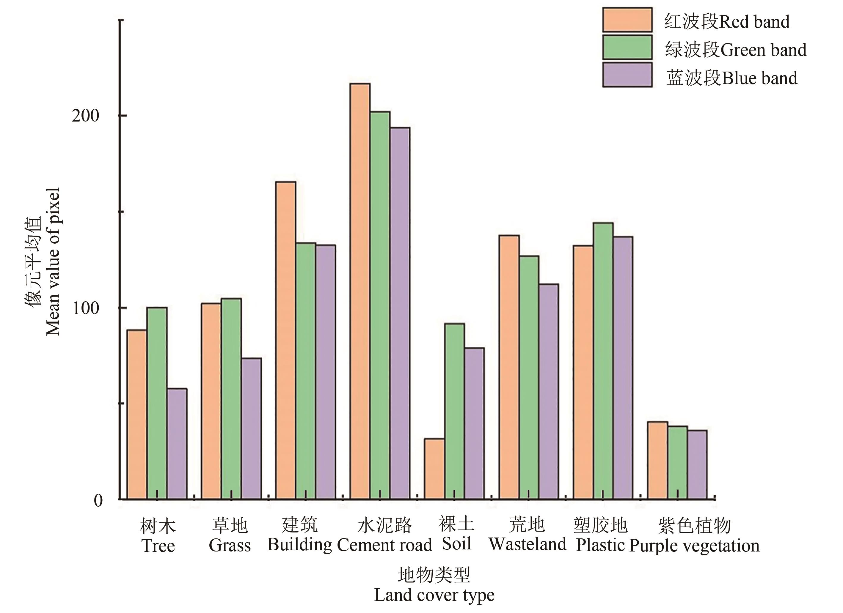
图1 研究区不同地物不同波段像元统计情况
Fig. 1 Statistics of different ground feature pixels at different bands
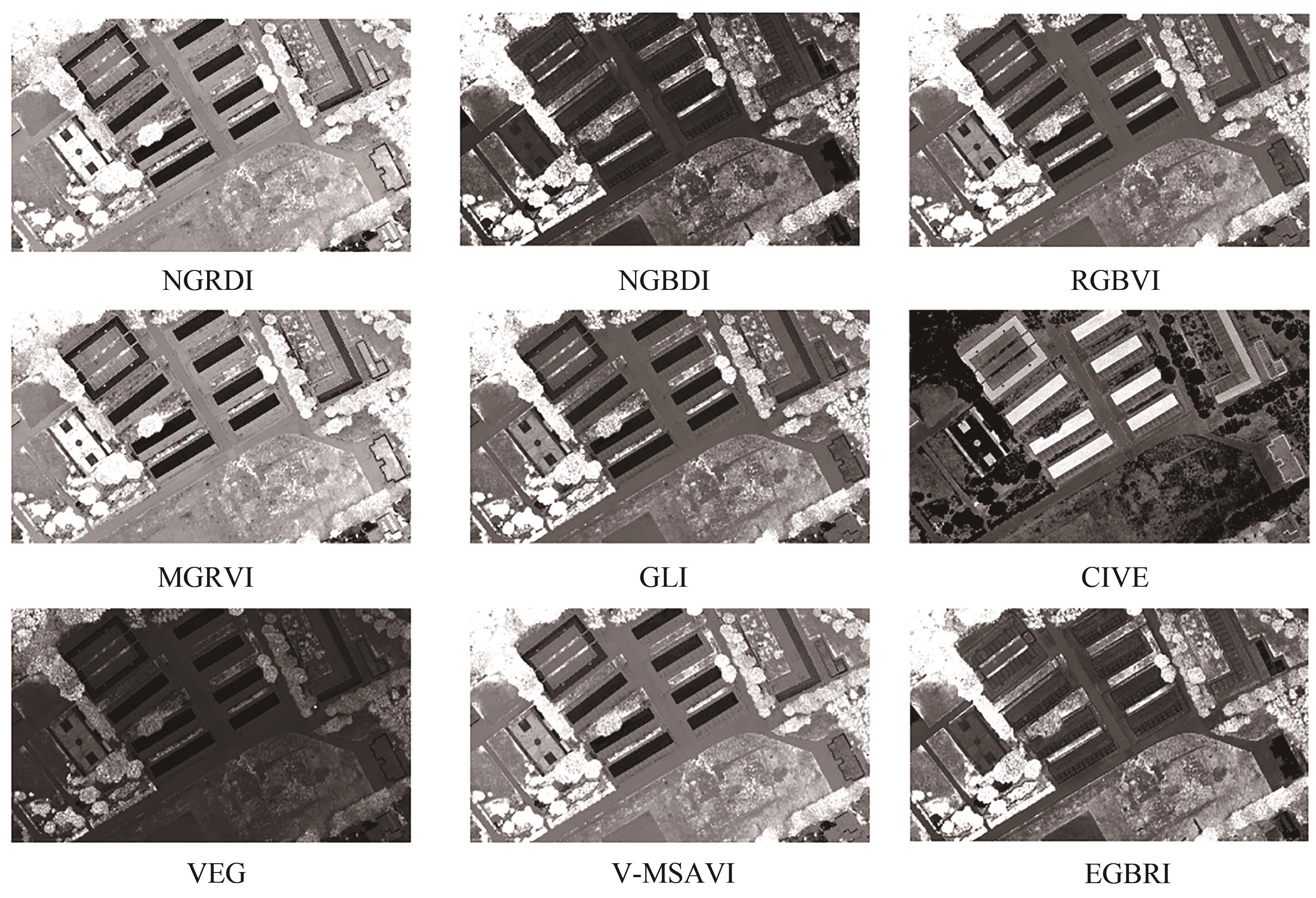
图2 不同可见光植被指数计算结果
Fig.2 Calculation results of each visible vegetation index
植被指数 Vegetation index | 树木 Tree | 草地 Grass | 建筑 Building | 水泥路 Cement road | 裸土 Soil | 荒地 Wasteland | 塑胶地 Plastic | 紫色植物 Purple vegetation |
|---|---|---|---|---|---|---|---|---|
| NGRDI | 0.073 3±0.062 9 | 0.570 4±0.043 9 | -0.1005±0.090 3 | -0.035 3±0.016 6 | 0.595 0±0.029 6 | -0.040 2±0.018 2 | 0.037 8±0.072 5 | -0.018 7±0.068 7 |
| NGBDI | 0.288 4±0.168 7 | 0.183 7±0.079 4 | 0.004 2±0.031 3 | 0.021 3±0.010 1 | 0.074 2±0.037 9 | 0.064 4±0.028 2 | 0.028 3±0.022 1 | 0.034 6±0.066 1 |
| RGBVI | 0.347 2±0.188 1 | 0.194 2±0.091 6 | -0.096 5±0.082 3 | -0.014 1±0.013 6 | -0.032 5±0.052 9 | 0.024 2±0.038 9 | 0.065 9±0.073 7 | 0.016 7±0.113 1 |
| MGRVI | 0.143 9±0.121 4 | 0.023 1±0.070 7 | -0.194 4±0.172 9 | -0.070 5±0.033 1 | -0.208 6±0.094 4 | -0.080 2±0.036 2 | 0.074 3±0.143 1 | -0.035 8±0.128 9 |
| GLI | 0.241 3±0.141 9 | 0.124 1±0.060 7 | -0.070 2±0.059 7 | -0.010 6±0.009 5 | -0.033 7±0.039 6 | 0.012 5±0.025 3 | 0.043 2±0.050 1 | 0.009 9±0.077 2 |
| CIVE | 18.668 0±0.059 6 | 18.71 9±0.025 5 | 18.801 0±0.027 5 | 18.774 0±0.004 4 | 18.787 0±0.017 8 | 18.765 0±0.010 7 | 18.750±0.022 8 | 18.766 0±0.033 4 |
| VEG | 1.387 3±0.323 5 | 1.154 9±0.102 6 | 0.881 3±0.100 9 | 0.967 7±0.018 4 | 0.912 7±0.057 0 | 0.990 0±0.035 6 | 1.077 3±0.105 6 | 1.004 7±0.110 9 |
| V-MSAVI | 0.552 5±0.264 0 | 0.323 1±0.134 6 | -0.090 8±0.071 2 | -0.032 3±0.029 5 | -0.109 4±0.134 9 | 0.035 0±0.073 7 | 0.117 5±0.137 3 | 0.007 5±0.314 3 |
| EGBRI | 0.835 4±0.086 8 | 0.781 1±0.051 7 | 0.603 8±0.040 2 | 0.626 4±0.012 2 | 0.684 8±0.040 3 | 0.675 1±0.030 5 | 0.634 3±0.025 5 | 0.636 1±0.091 8 |
表2 不同地类可见光植被指数统计值
Table 2 Visible vegetation index and its calculation method
植被指数 Vegetation index | 树木 Tree | 草地 Grass | 建筑 Building | 水泥路 Cement road | 裸土 Soil | 荒地 Wasteland | 塑胶地 Plastic | 紫色植物 Purple vegetation |
|---|---|---|---|---|---|---|---|---|
| NGRDI | 0.073 3±0.062 9 | 0.570 4±0.043 9 | -0.1005±0.090 3 | -0.035 3±0.016 6 | 0.595 0±0.029 6 | -0.040 2±0.018 2 | 0.037 8±0.072 5 | -0.018 7±0.068 7 |
| NGBDI | 0.288 4±0.168 7 | 0.183 7±0.079 4 | 0.004 2±0.031 3 | 0.021 3±0.010 1 | 0.074 2±0.037 9 | 0.064 4±0.028 2 | 0.028 3±0.022 1 | 0.034 6±0.066 1 |
| RGBVI | 0.347 2±0.188 1 | 0.194 2±0.091 6 | -0.096 5±0.082 3 | -0.014 1±0.013 6 | -0.032 5±0.052 9 | 0.024 2±0.038 9 | 0.065 9±0.073 7 | 0.016 7±0.113 1 |
| MGRVI | 0.143 9±0.121 4 | 0.023 1±0.070 7 | -0.194 4±0.172 9 | -0.070 5±0.033 1 | -0.208 6±0.094 4 | -0.080 2±0.036 2 | 0.074 3±0.143 1 | -0.035 8±0.128 9 |
| GLI | 0.241 3±0.141 9 | 0.124 1±0.060 7 | -0.070 2±0.059 7 | -0.010 6±0.009 5 | -0.033 7±0.039 6 | 0.012 5±0.025 3 | 0.043 2±0.050 1 | 0.009 9±0.077 2 |
| CIVE | 18.668 0±0.059 6 | 18.71 9±0.025 5 | 18.801 0±0.027 5 | 18.774 0±0.004 4 | 18.787 0±0.017 8 | 18.765 0±0.010 7 | 18.750±0.022 8 | 18.766 0±0.033 4 |
| VEG | 1.387 3±0.323 5 | 1.154 9±0.102 6 | 0.881 3±0.100 9 | 0.967 7±0.018 4 | 0.912 7±0.057 0 | 0.990 0±0.035 6 | 1.077 3±0.105 6 | 1.004 7±0.110 9 |
| V-MSAVI | 0.552 5±0.264 0 | 0.323 1±0.134 6 | -0.090 8±0.071 2 | -0.032 3±0.029 5 | -0.109 4±0.134 9 | 0.035 0±0.073 7 | 0.117 5±0.137 3 | 0.007 5±0.314 3 |
| EGBRI | 0.835 4±0.086 8 | 0.781 1±0.051 7 | 0.603 8±0.040 2 | 0.626 4±0.012 2 | 0.684 8±0.040 3 | 0.675 1±0.030 5 | 0.634 3±0.025 5 | 0.636 1±0.091 8 |
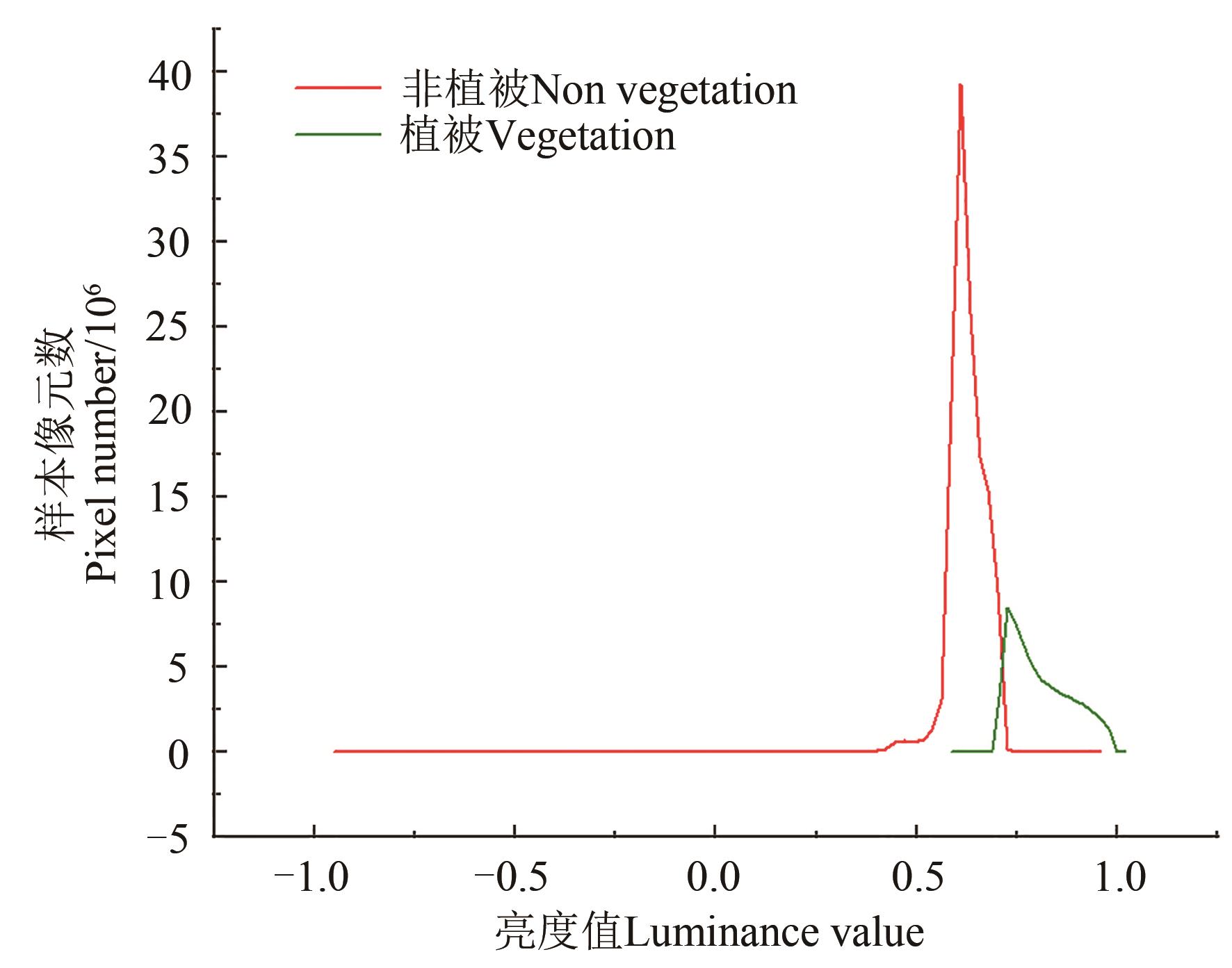
图3 EGBRI指数统计直方图
Fig. 3 Statistical histogram of EGBRI
植被指数 Vegetation index | 双峰直方图分割法 Bimodal histogram method | Otsu’s阈值分割法 Otsu’s method |
|---|---|---|
| EGBRI | 0.731 8 | 0.741 2 |
| NGRDI | 0.034 8 | 0.058 8 |
| NGBDI | 0.174 6 | 0.185 2 |
| RGBVI | 0.188 1 | 0.227 5 |
| MGRVI | 0.070 6 | 0.113 7 |
| GLI | 0.122 1 | 0.160 8 |
| CIVE | 18.706 5 | 18.721 3 |
| VEG | 1.254 8 | 1.121 8 |
| V-MSAVI | 0.369 4 | 0.325 5 |
表3 不同分割法所得阈值
Table 3 Visible vegetation index and its calculation method
植被指数 Vegetation index | 双峰直方图分割法 Bimodal histogram method | Otsu’s阈值分割法 Otsu’s method |
|---|---|---|
| EGBRI | 0.731 8 | 0.741 2 |
| NGRDI | 0.034 8 | 0.058 8 |
| NGBDI | 0.174 6 | 0.185 2 |
| RGBVI | 0.188 1 | 0.227 5 |
| MGRVI | 0.070 6 | 0.113 7 |
| GLI | 0.122 1 | 0.160 8 |
| CIVE | 18.706 5 | 18.721 3 |
| VEG | 1.254 8 | 1.121 8 |
| V-MSAVI | 0.369 4 | 0.325 5 |
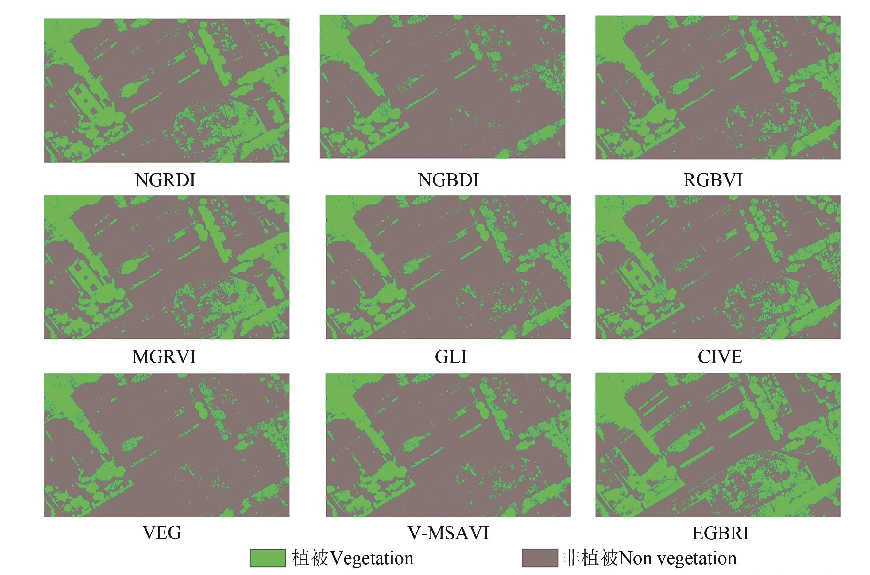
图4 不同可见光植被指数植被信息提取结果
Fig.4 Calculation results of vegetation index under different visible light
植被指数 Vegetation index | 精度Accuracy/% | Kappa系数 Kappa coefficient | ||
|---|---|---|---|---|
| 植被Vegetation | 非植被 Non vegetation | 总体精度Total | ||
| EGBRI | 95.24 | 90.36 | 95.06 | 0.889 5 |
| NGRDI | 89.85 | 88.21 | 88.92 | 0.731 2 |
| NGBDI | 100.00 | 79.42 | 82.45 | 0.527 6 |
| RGBVI | 98.46 | 86.78 | 89.31 | 0.747 2 |
| MGRVI | 89.86 | 76.26 | 88.76 | 0.669 8 |
| GLI | 98.75 | 83.79 | 86.12 | 0.662 5 |
| CIVE | 94.63 | 85.72 | 87.24 | 0.692 3 |
| VEG | 97.44 | 79.11 | 80.74 | 0.491 3 |
| V-MSAVI | 98.860 | 83.81 | 86.71 | 0.661 9 |
表4 不同可见光植被指数提取精度评价
Table 4 Evaluation of accuracy of extracting different visible light vegetation indices
植被指数 Vegetation index | 精度Accuracy/% | Kappa系数 Kappa coefficient | ||
|---|---|---|---|---|
| 植被Vegetation | 非植被 Non vegetation | 总体精度Total | ||
| EGBRI | 95.24 | 90.36 | 95.06 | 0.889 5 |
| NGRDI | 89.85 | 88.21 | 88.92 | 0.731 2 |
| NGBDI | 100.00 | 79.42 | 82.45 | 0.527 6 |
| RGBVI | 98.46 | 86.78 | 89.31 | 0.747 2 |
| MGRVI | 89.86 | 76.26 | 88.76 | 0.669 8 |
| GLI | 98.75 | 83.79 | 86.12 | 0.662 5 |
| CIVE | 94.63 | 85.72 | 87.24 | 0.692 3 |
| VEG | 97.44 | 79.11 | 80.74 | 0.491 3 |
| V-MSAVI | 98.860 | 83.81 | 86.71 | 0.661 9 |
研究区 Research area | 精度Accuracy/% | Kappa系数 Kappa coefficient | ||
|---|---|---|---|---|
| 植被Vegetation | 非植被 Non vegetation | 总体精度Total | ||
| 1 | 98.55 | 90.65 | 93.10 | 0.847 2 |
| 2 | 93.25 | 97.40 | 95.90 | 0.908 1 |
| 3 | 92.90 | 94.25 | 94.95 | 0.882 8 |
表5 研究区不同可见光植被指数提取效果
Table 5 Vegetation extraction effects of different visible light vegetation indices in research area
研究区 Research area | 精度Accuracy/% | Kappa系数 Kappa coefficient | ||
|---|---|---|---|---|
| 植被Vegetation | 非植被 Non vegetation | 总体精度Total | ||
| 1 | 98.55 | 90.65 | 93.10 | 0.847 2 |
| 2 | 93.25 | 97.40 | 95.90 | 0.908 1 |
| 3 | 92.90 | 94.25 | 94.95 | 0.882 8 |

图5 EGBRI可行性验证结果A:研究区1;B:研究区2;C:研究区3A:Research area 1; B:Research area 2; C:Research area 3
Fig. 5 EGBRI feasibility verification results
| 1 | MOHAMED H, ZAHRA L, NASER E S. A New Vegetation segmentation approach for cropped fields based on threshold detection from hue histograms [J/OL]. Sensors, 2018, 18(4): 1253 [2024-02-28]. . |
| 2 | 李德仁,李明.无人机遥感系统的研究进展与应用前景[J].武汉大学学报(信息科学版), 2014, 39(5):505-513, 540. |
| LI D R, LI M. Research advance and application prospect of unmanned aerial vehicle remote sensing system [J]. Geom. Inform. Sci. Wuhan Univ., 2014, 39(5):505-513, 540. | |
| 3 | 刘洋,祁琼.无人机航摄技术在国土资源领域的应用[J].地理空间信息, 2014, 12(1):29-30, 39. |
| LIU Y, QI Q. Application of unmanned arial technology in the field of land and resources [J]. Geospatial Inform., 2014, 12(1):29-30, 39. | |
| 4 | 范培新.国土资源执法监察中对无人机的应用实践[J].中小企业管理与科技, 2017,(3):88-89. |
| FAN P X. Application practice of UAV in law enforcement and supervision of land and resources [J]. Manage. Technol. SME, 2017 (3):88-89. | |
| 5 | 胡健波,张健.无人机遥感在生态学中的应用进展[J].生态学报,2018,38(1):20-30. |
| HU J B, ZHANG J. Unmanned aerial vehicle remote sensing in ecology: advances and prospects [J]. Acta Ecol. Sin., 2018,38(1):20-30. | |
| 6 | 刘珊珊,牛超杰,王建雄,等.NDVI在禄劝县植被变化特征分析中的应用[J].山东农业科学,2017,49(2):117-119, 131. |
| LIU S S, NIU C J, WANG J X, et al.. Application of NDVI in analysis of vegetation change characteristics in Luquan county of Yunnan province [J].Shandong Agric. Sci., 2017,49(2):117-119, 131. | |
| 7 | 边琳,叶飞,刘珊珊,等. 基于NDVI的昆明市2001—2015年植被覆盖变化趋势分析[J].山东农业科学,2018,50(1):107-110. |
| BIAN L, YE F, LIU S S, et al.. Change trend of vegetation cover in Kunming based on NDVI during 2001-2015 [J]. Shandong Agric. Sci., 2018,50(1):107-110. | |
| 8 | 杨杰,张莹莹,王建雄,等.利用NDVI与EVI再合成的植被指数算法[J].遥感信息,2020,35(5):127-133. |
| YANG J, ZHANG Y Y, WANG J X, et al.. Vegetation Index algorithm using NDVI and EVI resythesis [J]. Remote Sens. Inf., 2020,35(5):127-133. | |
| 9 | 边琳,叶飞,王建雄. 基于无人机低空多光谱遥感监测的烤烟株高研究[J]. 山东农业科学,2020,52(12):126-132. |
| BIAN L, YE F, WANG J X. Research on plant height of flue-cured tobacco based on UAV low-altitude multispectral remote sensing monitoring [J]. Shandong Agric. Sci.,2020,52(12):126-132. | |
| 10 | 牛鲁燕,蒋风伟,张俊丽,等.基于无人机多光谱遥感的小麦长势监测研究[J].山东农业科学,2021,53(3):139-145. |
| NIU L Y, JIANG F W, ZHANG J L, et al.. Study on wheat growth monitoring based on UAV multi-spectrum [J]. Shandong Agric. Sci., 2021, 53(3):139-145. | |
| 11 | 杨柳,陈延辉,岳德鹏,等.无人机遥感影像的城市绿地信息提取[J].测绘科学,2017,42(2):59-64. |
| YANG L, CHEN Y H, YUE D P, et al.. Information extraction of urban green space based on UAV remote sensing image [J]. Sci. Survey. Map., 2017, 42(2):59-64. | |
| 12 | 凌成星,刘华,纪平,等.基于无人机影像VDVI指数的植被覆盖度估算——以陕西神木防护林工程研究区为例[J].森林工程,2021,37(2):57-66. |
| LING C X, LIU H, JI P, et al.. Estimation of vegetation coverage based on VDVI index of UAV visible image—using the shelterbelt research area as an example [J]. Forest Eng., 2021,37(2):57-66. | |
| 13 | 程滔,管林杰,郑新燕,等.基于色调饱和度亮度模型的可见光植被提取[J].测绘通报,2022(2):116-120. |
| CHEN T, GUAN L J, ZHENG X Y, et al.. Visible light vegetation extraction of hue saturation and lightness color model [J]. Bull. Survey. Map., 2022(2):116-120. | |
| 14 | 高永刚,林悦欢,温小乐,等.基于无人机影像的可见光波段植被信息识别[J].农业工程学报,2020,36(3):178-189. |
| GAO Y G, LIN Y H, WEN X L, et al.. Vegetation information recognition in visible band based on UAV images [J]. Trans. Chin. Soc. Agric. Eng., 2020,36(3):178-189. | |
| 15 | 李了了,邓善熙,丁兴号.基于大津法的图像分块二值化算法[J].微计算机信息,2005(14):76-77. |
| LI L L, DENG S X, DING X H. Binarization algorithm based on image partition derived from da-jin method [J]. Microcomputer Information, 2005(14):76-77.[16] . | |
| 16 | WOEBBECKED M, MEYERG E, BARGENK V, et al.. Plant species identification, size, and enumeration using machine vision techniques on near-binary images [J]. SPIE Proc., 1993,1836: 208-219. |
| 17 | HUNT E R, CAVIGELLI M, DAUGHTRY C S T, et al.. Evaluation of digital photography from model aircraft for remote sensing of crop biomass and nitrogen status [J]. Precision Agric., 2005, 6:359-378. |
| 18 | BENDING J, YU K, AASEN H, et al.. Combining UAV-based plant height from crop surface models, visible, and near infrared vegetation indices for biomass monitoring in barley [J]. Int. J. Appl. Earth Observ. Geoinform., 2015, 39:79-87. |
| 19 | LOUHAICHI M, BORMAN M M, JOHNSON D E. Spatially located platform and aerial photography for documentation of grazing impacts on wheat [J]. Geocarto Int., 2001,16(1):65-70. |
| 20 | KATAOKA T, KANEKO T, OKAMOTO H, et al.. Crop growth estimation system using machine vision [C]// Proceedings of IEEE/ASME International Conference on Advanced Intelligent Mechatronics. IEEE Xplore,2003:1079-1083. |
| 21 | HAGUET, TILLETTN D, WHEELERH. Automated crop and weed monitoring in widely spaced cereals [J]. Precision Agric., 2006,7(1):21-32. |
| 22 | 周在明,杨燕明,陈本清. 基于可见光波段无人机影像的入侵物种互花米草提取研究[J]. 亚热带资源与环境学报,2017,12(2):90-95. |
| ZHOU Z M, YANG Y M, CHEN B Q. Study on the extraction of exotic species spartina alterniflora from UAV visible images [J]. J. Subtropical Resour. Environ., 2017,12(2):90-95. |
| [1] | 王薇, 付虹雨, 卢建宁, 岳云开, 杨瑞芳, 崔国贤, 佘玮. 基于无人机航拍的苎麻倒伏信息解译研究[J]. 中国农业科技导报, 2024, 26(3): 91-97. |
| [2] | 唐天君, 陈洋, 胡军, 江浩田. 基于无人机影像数据的烟草精准识别方法研究[J]. 中国农业科技导报, 2024, 26(10): 145-157. |
| [3] | 王建华, 温晓蕾, 栗佳宁, 郭思柔, 赵春明, 母时风, 赵德轩, 齐慧霞. 不同施药方式对板栗红蜘蛛田间防效和效益分析[J]. 中国农业科技导报, 2023, 25(5): 139-146. |
| [4] | 尹林江, 李威, 赵卫权, 赵祖伦, 吕思思, 孙小琼. 水稻多时相植被指数特征及覆盖度提取研究[J]. 中国农业科技导报, 2023, 25(2): 83-98. |
| [5] | 郭倩, 魏嘉豪, 张健, 叶章熙, 张厚喜, 赖正清, 邓辉. 基于无人机多光谱影像和随机森林的蔬菜识别[J]. 中国农业科技导报, 2023, 25(2): 99-110. |
| [6] | 卢闯, 胡海棠, 覃苑, 淮贺举, 李存军. 基于无人机多光谱影像的春玉米田管理分区研究[J]. 中国农业科技导报, 2022, 24(9): 106-115. |
| [7] | 胡灵炆, 周忠发, 尹林江, 朱孟, 黄登红. 基于无人机RGB影像的苗期油菜识别[J]. 中国农业科技导报, 2022, 24(9): 116-128. |
| [8] | 张静, 郭思梦, 韩迎春, 雷亚平, 邢芳芳, 杜文丽, 李亚兵, 冯璐. 基于无人机RGB图像的棉花产量估算[J]. 中国农业科技导报, 2022, 24(11): 112-120. |
| [9] | 张冠宏, 王新军, 徐晓龙, 闫立男, 常梦迪, 李永康, . 基于面向对象的无人机遥感影像荒漠植被分类[J]. 中国农业科技导报, 2021, 23(5): 69-77. |
| [10] | 伏荣桃,陈诚,王剑,陈雪娟,卢代华*. 植保无人机对水稻病虫害防治条件与防效的研究[J]. 中国农业科技导报, 2021, 23(4): 103-109. |
| [11] | 周恺1,周彤1,丁峰2,丁大伟2,武威1,姚照胜1,刘涛1,霍中洋1,孙成明1*. 基于无人机图像的小麦主要生育时期LAI估算[J]. 中国农业科技导报, 2021, 23(1): 89-97. |
| [12] | 王冰洁1,潘波1,姜蕾1,林勇1*,赵帅2,莫宇星2. 植保无人机作业参数对雾滴在火龙果树冠层沉积分布的影响[J]. 中国农业科技导报, 2020, 22(10): 101-109. |
| [13] | 徐朋1,徐伟诚2,罗阳帆2,赵祚喜2*. 基于无人机可见光遥感影像的耕地精准分类方法研究[J]. 中国农业科技导报, 2019, 21(6): 79-86. |
| [14] | 徐伟诚1,陈凯1,张铭1,李正风2,张天顺1*. 基于太阳能的植保无人机续航提升方案[J]. 中国农业科技导报, 2018, 20(11): 62-68. |
| 阅读次数 | ||||||
|
全文 |
|
|||||
|
摘要 |
|
|||||
 京公网安备11010802021197号