


中国农业科技导报 ›› 2022, Vol. 24 ›› Issue (9): 177-187.DOI: 10.13304/j.nykjdb.2021.0371
• 生物制造 资源生态 • 上一篇
齐丽1,2( ), 何振嘉1
收稿日期:2021-05-07
接受日期:2021-07-26
出版日期:2022-09-15
发布日期:2022-10-11
作者简介:齐丽 E-mail:420778295@qq.com
基金资助:
Li QI1,2(), Zhenjia HE1
Received:2021-05-07
Accepted:2021-07-26
Online:2022-09-15
Published:2022-10-11
摘要:
为探寻抑制土地荒漠化的适宜土地利用模式,分析北方农牧交错带花生种植模式对荒漠化的影响。以辽宁省阜新市彰武县北部主要花生种植区的不同土地利用种植模式为研究对象,对该地区2020年多时相遥感影像的物候特征和作物光谱特征进行相关分析,并在此基础上现场采集土壤样本,应用化学实验方法,结合SPSS等软件构建荒漠化程度评价指标体系,运用累积曲线分级法将土地荒漠化程度划分为无荒漠化、轻度荒漠化、中度荒漠化、重度荒漠化4个等级,与课题组2015年该地区的荒漠化数据库进行荒漠化程度对比检验。结果表明,农林复合模式、沙平地防护林-花生模式、砂质丘陵防护林-花生模式、沙平地-花生模式、砂质丘陵-花生模式5种模式对减轻荒漠化的能力依次降低。农林复合模式、沙平地防护林-花生模式、砂质丘陵防护林-花生模式均有使荒漠化逆向演替的效果,但演替程度逐渐降低,其中农林复合模式是最适种植模式,砂质丘陵防护林-花生模式有一定的局限性;沙平地-花生、砂质丘陵-花生模式均有使荒漠化正向演替的效果,演替程度逐渐增加。通过对不同种植模式下的土地进行荒漠化评价,旨在分析不同种植模式对荒漠化演替方向的影响,以期为改善不合理种植模式提供参考。
中图分类号:
齐丽, 何振嘉. 北方农牧交错带花生种植模式对荒漠化的影响[J]. 中国农业科技导报, 2022, 24(9): 177-187.
Li QI, Zhenjia HE. Effects of Peanut Planting Modes on Desertification in the North Agro⁃pastoral Zone[J]. Journal of Agricultural Science and Technology, 2022, 24(9): 177-187.
| G:目标层 Target laye | B:准则层 Criterion layer | C:指标层 Index layer | 数据来源 Data source | |||
|---|---|---|---|---|---|---|
类型 Type | 指标序号 Number of index serial | 类型 Type | 指标序号 Number of index serial | 类型 Type | 指标序号 Number of index serial | |
| 彰武县北部荒漠化评价指标体系 Evaluation index system of desertification in the north of Zhangwu county | G1 | 遥感 Remote sensing | B1 | 地表反照率 Surface albedo/% | C1 | 遥感调查、模型计算 Remote sensing survey, model calculation |
| 植被覆盖指数 Normalized difference vegetation index/% | C2 | |||||
立地条件 Site conditions | B2 | 土壤砂黏比 Soil sand viscosity ratio/% | C3 | 土壤采样化验 Soil sampling test | ||
| 坡度 Slope /(°) | C4 | DEM数据库 DEM database | ||||
| 理化性状 Physical and chemical properties | B3 | 全氮 Total nitrogen/ (g·kg-1) | C5 | 土壤采样化验 Soil sampling test | ||
| 胡敏酸/富里酸 HA/FA/% | C6 | |||||
| 土壤有机质 Soil organic matter/(g·kg-1) | C7 | |||||
土地利用指数 Land use index | B4 | 林木平均半径 Average radius of forest/m | C8 | 实地调查 Field investigation | ||
农田防护林完备程度 Completeness of farmland shelterbelts/% | C9 | |||||
表1 彰武县北部荒漠化评价指标体系
Table 1 Desertification evaluation index system in the north of Zhangwu county
| G:目标层 Target laye | B:准则层 Criterion layer | C:指标层 Index layer | 数据来源 Data source | |||
|---|---|---|---|---|---|---|
类型 Type | 指标序号 Number of index serial | 类型 Type | 指标序号 Number of index serial | 类型 Type | 指标序号 Number of index serial | |
| 彰武县北部荒漠化评价指标体系 Evaluation index system of desertification in the north of Zhangwu county | G1 | 遥感 Remote sensing | B1 | 地表反照率 Surface albedo/% | C1 | 遥感调查、模型计算 Remote sensing survey, model calculation |
| 植被覆盖指数 Normalized difference vegetation index/% | C2 | |||||
立地条件 Site conditions | B2 | 土壤砂黏比 Soil sand viscosity ratio/% | C3 | 土壤采样化验 Soil sampling test | ||
| 坡度 Slope /(°) | C4 | DEM数据库 DEM database | ||||
| 理化性状 Physical and chemical properties | B3 | 全氮 Total nitrogen/ (g·kg-1) | C5 | 土壤采样化验 Soil sampling test | ||
| 胡敏酸/富里酸 HA/FA/% | C6 | |||||
| 土壤有机质 Soil organic matter/(g·kg-1) | C7 | |||||
土地利用指数 Land use index | B4 | 林木平均半径 Average radius of forest/m | C8 | 实地调查 Field investigation | ||
农田防护林完备程度 Completeness of farmland shelterbelts/% | C9 | |||||
| 指标 Index | B1 | B2 | B3 | B3 | 组合权重 Combination weight |
|---|---|---|---|---|---|
| C1 | 0.250 0 | 0.015 1 | |||
| C2 | 0.750 0 | 0.045 3 | |||
| C5 | 0.066 9 | 0.010 9 | |||
| C6 | 0.220 0 | 0.035 7 | |||
| C7 | 0.713 2 | 0.115 7 | |||
| C3 | 0.166 7 | 0.048 0 | |||
| C4 | 0.833 3 | 0.239 9 | |||
| C8 | 0.250 0 | 0.122 4 | |||
| C9 | 0.750 0 | 0.367 1 |
表2 荒漠化评价因子组合权重
Table 2 Combination weight of desertification evaluation factor
| 指标 Index | B1 | B2 | B3 | B3 | 组合权重 Combination weight |
|---|---|---|---|---|---|
| C1 | 0.250 0 | 0.015 1 | |||
| C2 | 0.750 0 | 0.045 3 | |||
| C5 | 0.066 9 | 0.010 9 | |||
| C6 | 0.220 0 | 0.035 7 | |||
| C7 | 0.713 2 | 0.115 7 | |||
| C3 | 0.166 7 | 0.048 0 | |||
| C4 | 0.833 3 | 0.239 9 | |||
| C8 | 0.250 0 | 0.122 4 | |||
| C9 | 0.750 0 | 0.367 1 |
评价因子 Evaluation factor | 分级 Grading | 隶属度 Membership |
|---|---|---|
| 林木平均半径 Average radius of forest/m | 0 | 0.1 |
| <50 | 0.4 | |
| 50~99 | 0.7 | |
| ≥100 | 0.9 | |
| 坡度 Slope/(°) | <2.0 | 0.9 |
| 2.0~5.9 | 0.5 | |
| ≥6.0 | 0.1 | |
农田防护林完备程度 Completeness of farmland shelterbelt | 无 No | 0.1 |
| 中等 Medium | 0.4 | |
| 良好 Good | 0.7 | |
| 优秀 Excellent | 0.9 |
表3 概念型评价因子隶属度
Table 3 The membership degree of generalizing evaluation factors
评价因子 Evaluation factor | 分级 Grading | 隶属度 Membership |
|---|---|---|
| 林木平均半径 Average radius of forest/m | 0 | 0.1 |
| <50 | 0.4 | |
| 50~99 | 0.7 | |
| ≥100 | 0.9 | |
| 坡度 Slope/(°) | <2.0 | 0.9 |
| 2.0~5.9 | 0.5 | |
| ≥6.0 | 0.1 | |
农田防护林完备程度 Completeness of farmland shelterbelt | 无 No | 0.1 |
| 中等 Medium | 0.4 | |
| 良好 Good | 0.7 | |
| 优秀 Excellent | 0.9 |
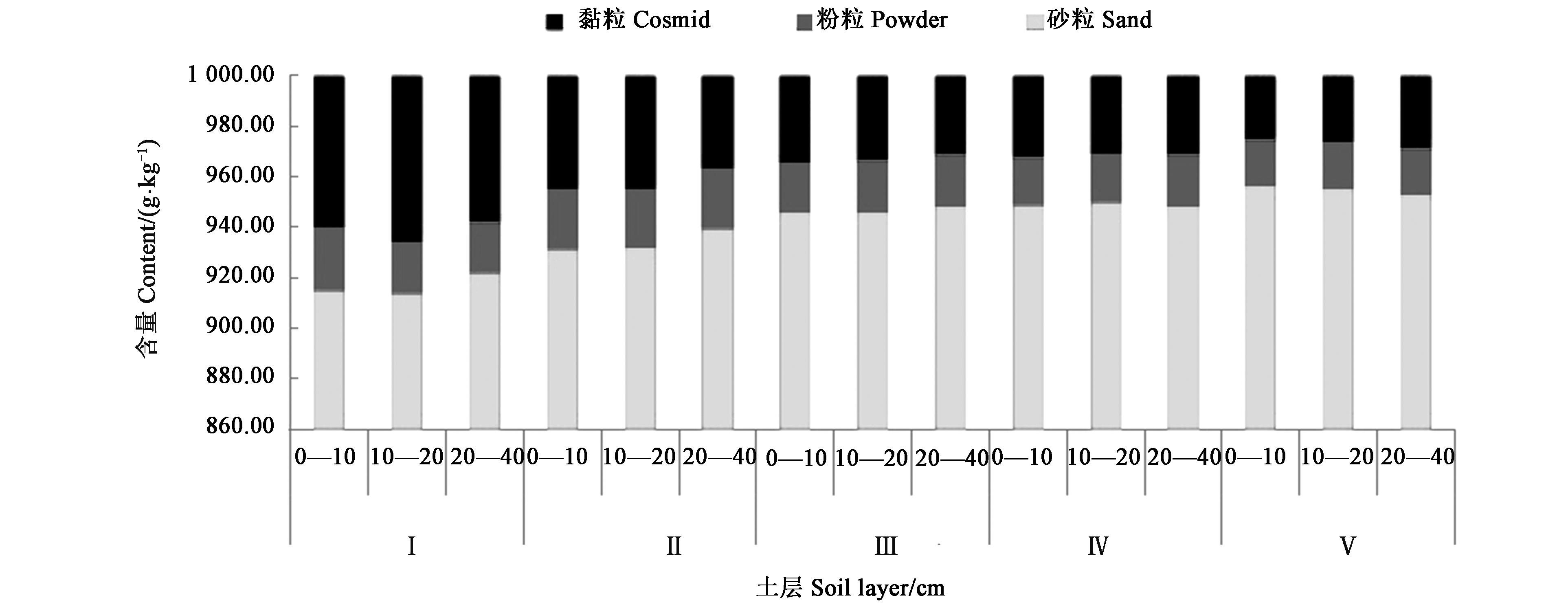
图1 不同种植模式下土壤剖面机械组成注:Ⅰ、Ⅱ、Ⅲ、Ⅳ和Ⅴ分别表示农林复合模式、沙平地防护林-花生模式、砂质丘陵防护林-花生模式、沙平地-花生模式、砂质丘陵-花生模式。
Fig.1 Mechanical composition of soil profile under different planting modesNote:Ⅰ,Ⅱ,Ⅲ,Ⅳ and Ⅴrepresent agroforestry mode, sand-flat shelterbelt-peanut mode, sandy hill shelterbelt-peanut mode, sandy-flat land-peanut mode, and sandy hill-peanut mode, respectively.
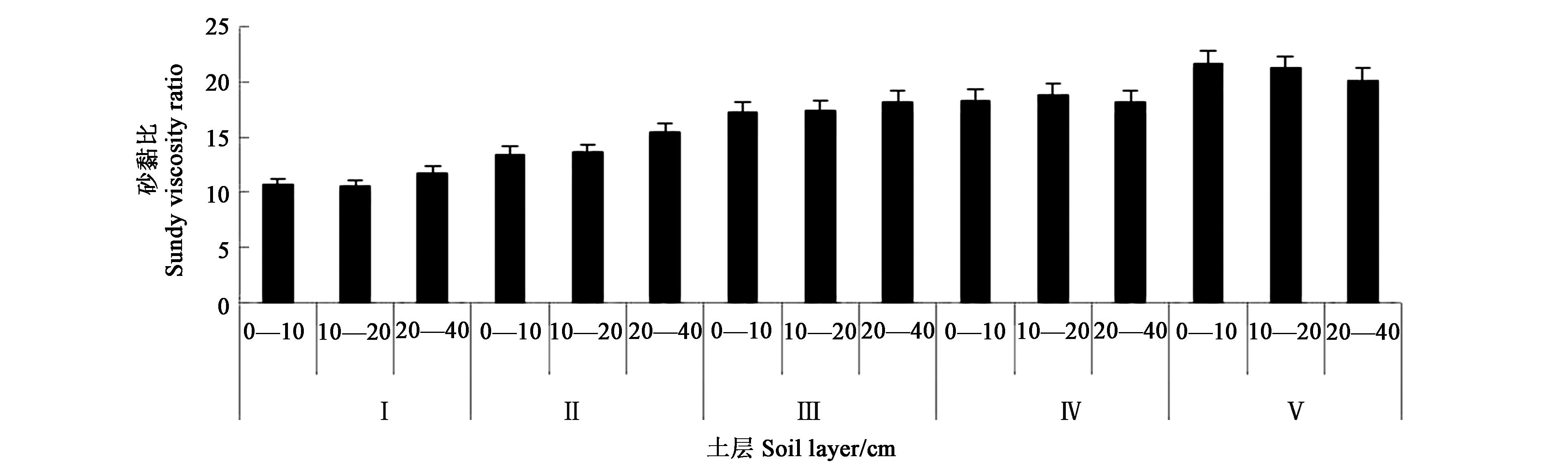
图2 不同种植模式下土壤剖面砂黏比注:Ⅰ、Ⅱ、Ⅲ、Ⅳ和Ⅴ分别表示农林复合模式、沙平地防护林-花生模式、砂质丘陵防护林-花生模式、沙平地-花生模式、砂质丘陵-花生模式。
Fig.2 Soil profile sand viscosity ratio under different planting modesNote:Ⅰ,Ⅱ,Ⅲ,Ⅳ and Ⅴrepresent agroforestry mode, sand-flat shelterbelt-peanut mode, sandy hill shelterbelt-peanut mode, sandy-flat land-peanut mode, and sandy hill-peanut mode, respectively.
利用模式 Utilization mode | 有机质平均含量 Average content of organic matter/(g·kg-1) | 差异显著性 Significant difference | |
|---|---|---|---|
| P=0.05 | P=0.01 | ||
农林复合 Agroforestry | 8.49 | a | A |
沙平地防护林-花生 Sand-flat shelterbelt-peanut | 7.34 | a | AB |
砂质丘陵防护林-花生 Sandy hill shelterbelt-peanut | 5.10 | b | BC |
沙平地-花生 Sandy-flat land-peanut model | 3.36 | b | BC |
砂质丘陵-花生 Sandy hill-peanut model | 2.56 | b | C |
表4 研究区表层土壤不同利用模式下有机质方差分析结果
Table 4 Analysis of variance results of organic matter under different utilization modes of topsoil in the study area
利用模式 Utilization mode | 有机质平均含量 Average content of organic matter/(g·kg-1) | 差异显著性 Significant difference | |
|---|---|---|---|
| P=0.05 | P=0.01 | ||
农林复合 Agroforestry | 8.49 | a | A |
沙平地防护林-花生 Sand-flat shelterbelt-peanut | 7.34 | a | AB |
砂质丘陵防护林-花生 Sandy hill shelterbelt-peanut | 5.10 | b | BC |
沙平地-花生 Sandy-flat land-peanut model | 3.36 | b | BC |
砂质丘陵-花生 Sandy hill-peanut model | 2.56 | b | C |
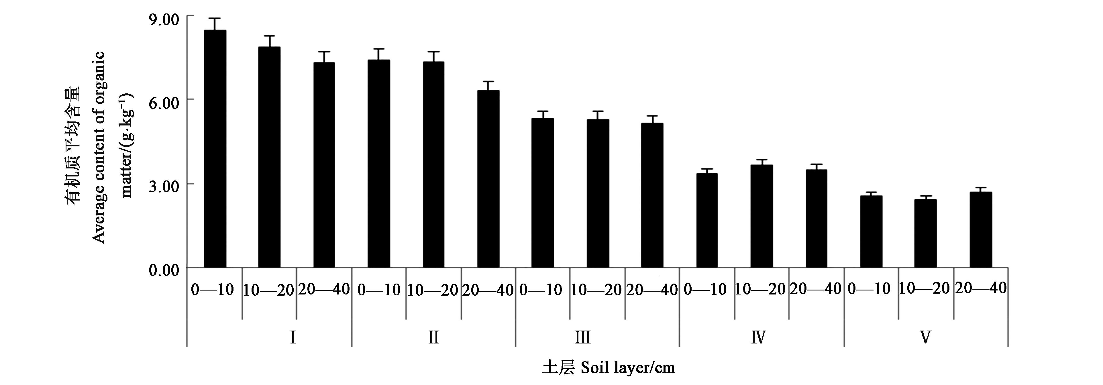
图3 不同利用模式下剖面有机质的变化情况注:Ⅰ、Ⅱ、Ⅲ、Ⅳ和Ⅴ分别表示农林复合模式、沙平地防护林-花生模式、砂质丘陵防护林-花生模式、沙平地-花生模式、砂质丘陵-花生模式。
Fig.3 Changes of profile organic matter under different utilization modesNote:Ⅰ,Ⅱ,Ⅲ,Ⅳ and Ⅴrepresent agroforestry mode, sand-flat shelterbelt-peanut mode, sandy hill shelterbelt-peanut mode, sandy-flat land-peanut mode, and sandy hill-peanut mode, respectively.
利用模式 Utilization mode | 全氮平均含量 Average total nitrogen content/ (g•kg-1) | 差异显著性 Significant difference | |
|---|---|---|---|
| P=0.05 | P=0.01 | ||
农林复合 Agroforestry | 1.02 | a | A |
沙平地防护林-花生 Sand-flat shelterbelt-peanut | 0.98 | ab | A |
砂质丘陵防护林-花生 Sandy hill shelterbelt-peanut | 0.88 | abc | AB |
沙平地-花生 Sandy-flat land-peanut | 0.74 | bc | AB |
砂质丘陵-花生 Sandy hill-peanut | 0.69 | d | B |
表5 研究区表层土壤不同利用模式下全氮含量方差分析结果
Table 5 Analysis of variance results of total nitrogen content in topsoil under different utilization modes in the study area
利用模式 Utilization mode | 全氮平均含量 Average total nitrogen content/ (g•kg-1) | 差异显著性 Significant difference | |
|---|---|---|---|
| P=0.05 | P=0.01 | ||
农林复合 Agroforestry | 1.02 | a | A |
沙平地防护林-花生 Sand-flat shelterbelt-peanut | 0.98 | ab | A |
砂质丘陵防护林-花生 Sandy hill shelterbelt-peanut | 0.88 | abc | AB |
沙平地-花生 Sandy-flat land-peanut | 0.74 | bc | AB |
砂质丘陵-花生 Sandy hill-peanut | 0.69 | d | B |
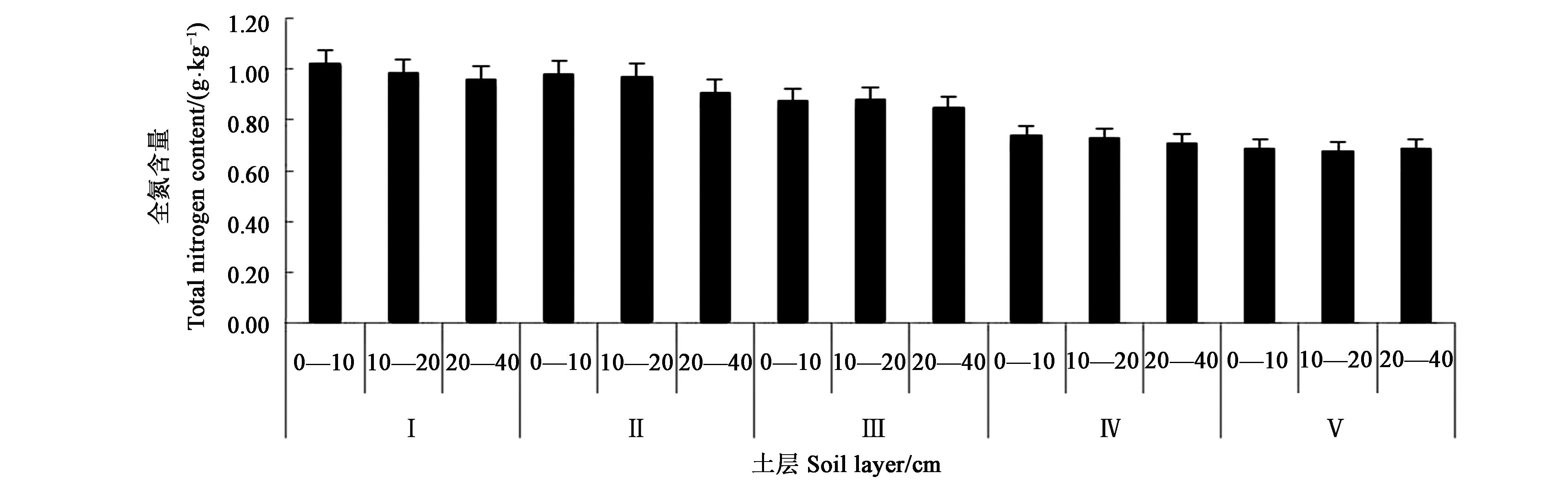
图4 不同利用模式土壤剖面全氮含量注:Ⅰ、Ⅱ、Ⅲ、Ⅳ和Ⅴ分别表示农林复合模式、沙平地防护林-花生模式、砂质丘陵防护林-花生模式、沙平地-花生模式、砂质丘陵-花生模式。
Fig.4 Total nitrogen content of soil profile under different utilization modesNote:Ⅰ,Ⅱ,Ⅲ,Ⅳ and Ⅴrepresent agroforestry mode, sand-flat shelterbelt-peanut mode, sandy hill shelterbelt-peanut mode, sandy-flat land-peanut mode, and sandy hill-peanut mode, respectively.
利用模式 Utilization mode | HA/FA | 差异显著性 Significant difference | |
|---|---|---|---|
| P=0.05 | P=0.01 | ||
农林复合 Agroforestry | 0.59 | a | A |
沙平地防护林-花生 Sand-flat shelterbelt-peanut | 0.54 | ab | A |
砂质丘陵防护林-花生 Sandy hill shelterbelt-peanut | 0.46 | abc | AB |
沙平地-花生 Sandy-flat land-peanut | 0.39 | bc | AB |
砂质丘陵-花生 Sandy hill-peanut | 0.33 | c | B |
表6 研究区表层土壤不同利用模式下HA/FA方差分析结果
Table 6 Analysis results of variance of HA / FA under different utilization modes of topsoil in the study area
利用模式 Utilization mode | HA/FA | 差异显著性 Significant difference | |
|---|---|---|---|
| P=0.05 | P=0.01 | ||
农林复合 Agroforestry | 0.59 | a | A |
沙平地防护林-花生 Sand-flat shelterbelt-peanut | 0.54 | ab | A |
砂质丘陵防护林-花生 Sandy hill shelterbelt-peanut | 0.46 | abc | AB |
沙平地-花生 Sandy-flat land-peanut | 0.39 | bc | AB |
砂质丘陵-花生 Sandy hill-peanut | 0.33 | c | B |
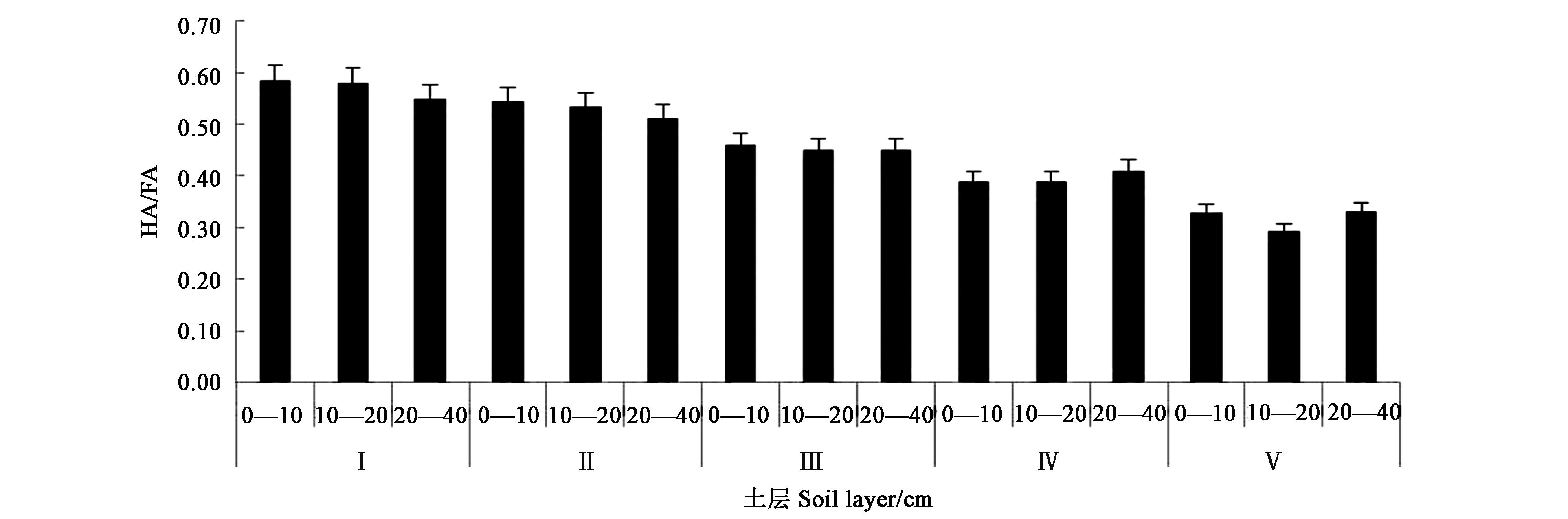
图5 不同利用模式土壤剖面HA/FA含量注:Ⅰ、Ⅱ、Ⅲ、Ⅳ和Ⅴ分别表示农林复合模式、沙平地防护林-花生模式、砂质丘陵防护林-花生模式、沙平地-花生模式、砂质丘陵-花生模式。
Fig.5 HA/FA content in soil profiles of different utilization modesNote:Ⅰ,Ⅱ,Ⅲ,Ⅳ and Ⅴrepresent agroforestry mode, sand-flat shelterbelt-peanut mode, sandy hill shelterbelt-peanut mode, sandy-flat land-peanut mode, and sandy hill-peanut mode, respectively.
| 1 | 廖兴亮,张腾,徐艳.半干旱区荒漠化演变趋势研究——以科尔沁左翼后旗为例[J].中国农业资源与区划,2020,41(4):299-307. |
| LIAO X L, ZHANG T, XU Y. Research on the evolution trend of desertification in semi-arid area: a case study of Kezuohouqi county [J]. Chin. J. Agric. Resour. Region Plan, 2020, 41(4): 299-307. | |
| 2 | 贾树海,王潇雪,杨亮.辽北农牧交错带土地荒漠化及景观格局变化研究[J].中国水土保持,2014(5):51-55, 73. |
| JIA S H, WANG X X, YANG L. Soil and water conservation in China [J]. Chin. Soil Water Conser., 2014(5): 51-55, 73. | |
| 3 | 宋乃平,卞莹莹,王磊,等.农牧交错带农牧复合系统的可持续机制[J].生态学报,2020,40(21):7931-7940. |
| SONG N P, BIAN Y Y, WANG L, et al.. Sustainable mechanism of agro-pastoral complex system in agro-pastoral ecotone [J]. Acta Ecol. Sin., 2020, 40(21): 7931-7940. | |
| 4 | 王涛.浑善达克沙区土地沙漠化过程及其生态环境效应[D].北京:北京林业大学,2020. |
| WANG T. The aeolian desertification dynamics and related ecological environment effect in the Otindag sandy land [D]. Beijing: Beijing Forestry University, 2020. | |
| 5 | 马明德,杨美玲.基于STIRPAT模型的农牧交错带草地面积变化影响因素分析——以宁夏回族自治区盐池县为例[J].中国农业资源与区划,2018,39(3):48-54. |
| MA M D, YANG M L. The influence factors of grassland area change in farming-pastoral transitional zone by stirpat model—a case of Yanchi county of Ningxia Hui autonomous region in China [J]. Chin. J. Agric. Resour. Region Plan, 2018, 39(3): 48-54. | |
| 6 | 李旭亮,杨礼箫,田伟,等.中国北方农牧交错带土地利用/覆盖变化研究综述[J].应用生态学报,2018,29(10):331-339. |
| LI X L, YANG L X, TIAN W, et al.. Land use and land cover change in agro-pastoral ecotone in Northern China:a review [J]. Chin. J. Appl. Ecoal., 2018, 29( 10): 3487-3495. | |
| 7 | 郭泽呈,魏伟,石培基,等.中国西北干旱区土地沙漠化敏感性时空格局[J].地理学报,2020,75(9):1948-1965. |
| GUO Z C, WEI W, SHI P J, et al.. Spatiotemporal changes of land desertification sensitivity in the arid region of Northwest China [J]. Acta Geogr. Sin., 2020, 75(9): 1948-1965. | |
| 8 | 崔向慧,却晓娥,杨柳.土地退化和荒漠化防治领域国际标准化现状与思考[J].中国水土保持科学,2020,18(6):147-152. |
| CUI X H, QUE X E, YANG L. Current status and thoughts on international standardization in the field of mitigating land degradation and combating desertification [J]. Sci.Soil Water Conser. Chin., 2020, 18(6): 147-152. | |
| 9 | 黄昌勇.土壤学[M].北京:中国农业出版社,2000:15-18, 31. |
| 10 | 何超,李萌,李婷婷,等.多目标综合评价中四种确定权重方法的比较与分析[J].湖北大学学报,2016,38(2):172-178. |
| HE C, LI M, LI T T, et al.. Comparison and analysis of the four methods of determining weights in multi-objective comprehensive evaluation [J]. J. Hubei Univ., 2016, 38(2): 172-178. | |
| 11 | 黄妙芬,邢旭峰,王培娟,等.利用LANDSAT/TM热红外通道反演地表温度的三种方法比较[J].干旱区地理,2006(1):132-137. |
| HUANG M F, XING X, WANG P J, et al.. Comparison between three different methods of retrieving surface temperature from LANDSAT/TM thermal infrared band [J]. Arid. Land Geogr., 2006(1): 132-137. | |
| 12 | 李雪. 辽宁地区耕地质量等别评价系统开发研究[D].阜新:辽宁工程技术大学,2017. |
| LI X. Research on the development of evaluation system of cultivated land quality in Liaoning [D]. Fuxin: Liaoning Technical University, 2017. | |
| 13 | 殷贺,李正国,王仰麟,等.基于时间序列植被特征的内蒙古荒漠化评价[J].地理学报,2011,66(5):653-661. |
| YIN H, LI Z G, WANG Y L, et al.. Assessment of desertification using time series analysis of hyper-temporal vegetation indicator in inner mongolia [J]. Acta Geogr. Sin., 2011, 66(5): 653-661. | |
| 14 | 新华社.习近平致信祝贺《联合国防治荒漠化公约》第十三次缔约方大会高级别会议召开[J].国土绿化,2017(9):6. |
| 15 | 张博. 1999-2018年青海省土地荒漠化遥感监测及其驱动力分析[D].北京:中国地质大学,2020. |
| ZHANG B. Remote sensing monitoring and driving force analysis of land desertification in Qinghai province from 1999 to 2018 [D]. Beijing: China University of Geosciences, 2020. | |
| 16 | MA Y, FAN S, ZHOU L, et al.. The temporal change of driving factors during the course of land desertification in arid region of North China: the case of Minqin county[J]. Environ.Geol., 2007, 51(6): 999-1008. |
| 17 | 张东杰.共和盆地近50年来草地荒漠化驱动因素定量研究[J].水土保持研究,2010,17(4):166-169. |
| ZHANG D J. Quantitative research of driving factors on grassland desertification over last 50 years in Gonghe basin [J]. Res. Soil Water Conse., 2010, 17(4): 166-169. | |
| 18 | 章予舒,王立新,张红旗,等.疏勒河流域土地利用变化驱动因素分析——以安西县为例[J].地理科学进展,2003(3):170-178. |
| ZHANG Y S, WANG L X, ZHANG H Q, et al.. An analysis on land use changes and their driving factors in shule river: an example from Anxi county [J]. Progr. Geogr., 2003(3): 170-178. | |
| 19 | 奥布力·塔力普,阿里木江·卡斯木.南疆地区经济发展对荒漠化程度的影响研究[J].冰川冻土,2017,39(1):220-228. |
| OBUL T, ALIMUJIANG K. Study of the social economic development impacting the desertification in southern Xinjiang [J]. J. Glac. Geocry., 2017, 39(1): 220-228. | |
| 20 | 何鹏杰,张恒嘉,王玉才,等.河西地区临泽县土地荒漠化影响因素分析[J].环境工程,2016,34(S1):1111-1116. |
| HE P J, ZHANG H J, WANG Y C, et al.. Analysis of influencing factors of land desertification of Hexi corridor of Linze county [J]. Environ. Eng., 2016, 34(S1): 1111-1116. |
| [1] | 戴良香, 张冠初, 丁红, 徐扬, 张智猛. 有机肥和钙肥对盐碱土花生根际细菌群落结构的影响[J]. 中国农业科技导报, 2022, 24(5): 189-201. |
| [2] | 胡婷, 全伟, 吴明亮, 李林. 双垄四行花生垄作播种机种沟开沟器设计与试验[J]. 中国农业科技导报, 2021, 23(9): 129-137. |
| [3] | 伊淼1,2§,王建国 2§,尹金1,郭峰2,张佳蕾2,唐朝辉2,李新国2,3*,万书波2,3*. 减氮增钙及施用时期对花生生长发育及生理特性的影响[J]. 中国农业科技导报, 2021, 23(4): 164-172. |
| [4] | 刘娜1,王彦1,赵晨阳2,郭俊先2. 日光温室辣椒机械化移栽可行性研究[J]. 中国农业科技导报, 2021, 23(2): 96-104. |
| [5] | 周巾英,王丽,祝水兰,罗晶,樊琪平,冯健雄*. 不同贮藏方式对花生仁品质的影响[J]. 中国农业科技导报, 2021, 23(2): 134-140. |
| [6] | 王钰云,王宏富*,李智,段宏凯,黄珊珊. 谷子花生间作对谷子光合特性及产量的影响[J]. 中国农业科技导报, 2020, 22(5): 153-165. |
| [7] | 王飞1,王建国2,李林1*,刘登望1*,万书波2,张昊1. 不同施肥模式对花生Ca、Zn吸收、积累及分配的影响[J]. 中国农业科技导报, 2020, 22(5): 166-173. |
| [8] | 李庆凯1,2,3,刘苹2,3*,赵海军3,宋效宗2,林海涛2,沈玉文2,李林1,万书波1,3*. 玉米根系分泌物对连作花生土壤酚酸类物质化感作用的影响[J]. 中国农业科技导报, 2020, 22(3): 119-130. |
| [9] | 张冠初1,2,张智猛1*,慈敦伟1,丁红1,杨吉顺1,史晓龙1,3,田家明1,3,戴良香1*. 不同品种花生耐盐性及Na+吸收动力学特性[J]. 中国农业科技导报, 2019, 21(2): 34-40. |
| [10] | 王琢1*,原克波1,李增绪1,闫培生2*. 抑制黄曲霉毒素前体合成的芽孢杆菌鉴定及其抑制活性研究[J]. 中国农业科技导报, 2019, 21(11): 111-120. |
| [11] | 董晓宇1,郭月峰1*,姚云峰1,秦富仓1,祁伟2,王欣3,王慧1. 柠条锦鸡儿根长与游离氨基酸分布特征研究[J]. 中国农业科技导报, 2019, 21(10): 66-73. |
| [12] | 张俊,刘娟,臧秀旺,郝西,汤丰收,董文召*,张忠信,苗利娟,刘华. 不同种植方式密植对花生开花结实的影响[J]. 中国农业科技导报, 2019, 21(1): 125-131. |
| [13] | 孙颖材,董泰丽*. 能源玉米不同种植模式下土地甲烷产量的研究[J]. 中国农业科技导报, 2018, 20(7): 91-97. |
| [14] | 张俊1,刘娟1,臧秀旺1,郝西1,汤丰收1*,董文召1,张忠信1,苗利娟1,宋新莉2. 不同贮藏方式下花生种子萌发能力及生理变化研究[J]. 中国农业科技导报, 2018, 20(6): 19-27. |
| [15] | 顾勇1,谢云波1,张永辉1,蔡艳2,沈杰2,宋杨2,周泽弘2,李斌3,李冰2*. 不同种植模式下烤烟干物质积累与养分吸收动态变化分析[J]. 中国农业科技导报, 2018, 20(4): 115-122. |
| 阅读次数 | ||||||
|
全文 |
|
|||||
|
摘要 |
|
|||||
 京公网安备11010802021197号