


Journal of Agricultural Science and Technology ›› 2022, Vol. 24 ›› Issue (9): 106-115.DOI: 10.13304/j.nykjdb.2021.0618
• INTELLIGENT AGRICULTURE & AGRICULTURAL MACHINERY • Previous Articles
Chuang LU1( ), Haitang HU1, Yuan QIN1,2, Heju HUAI1, Cunjun LI1()
Received:2021-07-27
Accepted:2021-11-22
Online:2022-09-15
Published:2022-10-11
Contact:
Cunjun LI
卢闯1(), 胡海棠1, 覃苑1,2, 淮贺举1, 李存军1()
通讯作者:
李存军
作者简介:卢闯 E-mail: lupeichuang@163.com;
基金资助:CLC Number:
Chuang LU, Haitang HU, Yuan QIN, Heju HUAI, Cunjun LI. Delineating Management Zones in Spring Maize Field Based on UAV Multispectral Image[J]. Journal of Agricultural Science and Technology, 2022, 24(9): 106-115.
卢闯, 胡海棠, 覃苑, 淮贺举, 李存军. 基于无人机多光谱影像的春玉米田管理分区研究[J]. 中国农业科技导报, 2022, 24(9): 106-115.
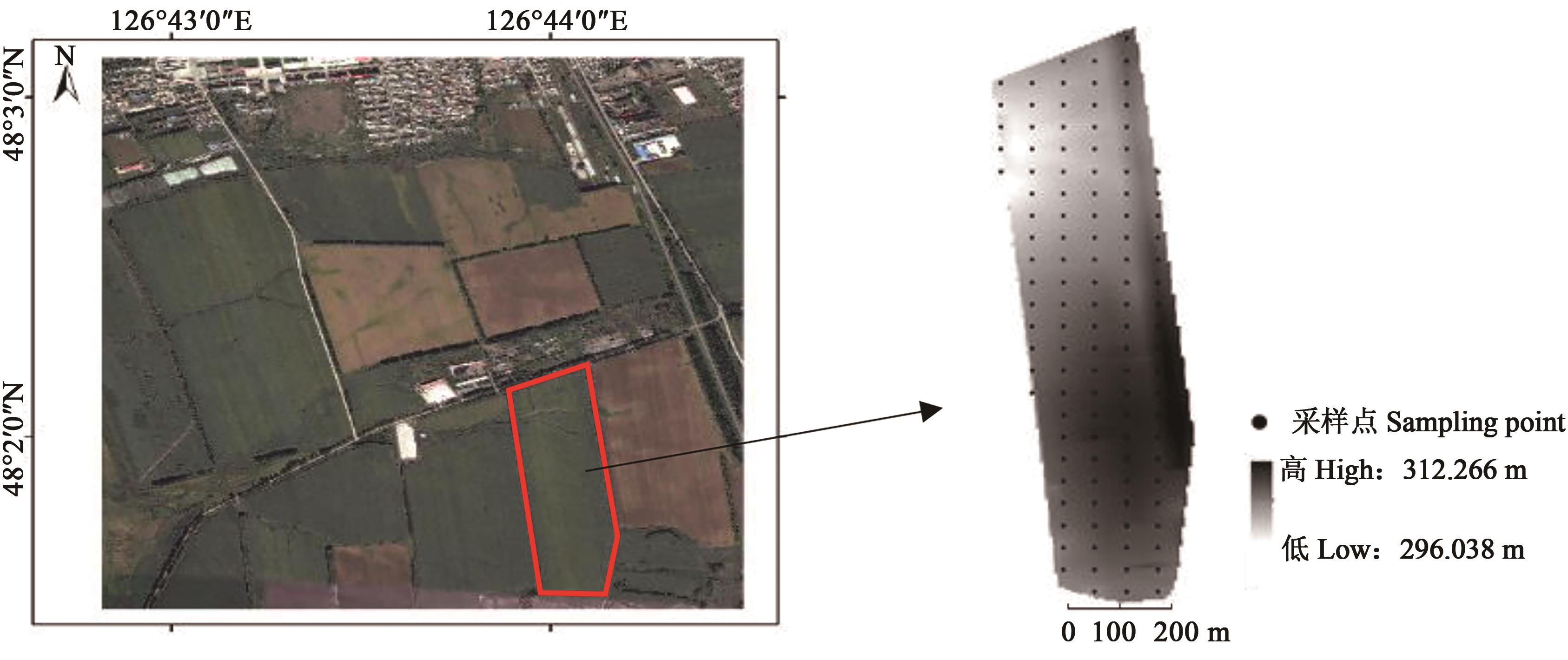
Fig. 1 Research area
| 土壤指标 Soil properties | 样点数目 Sample points No. | 平均值Average | 最小值Min. | 最大值Max. | 变异系数CV | 偏度Skewness | 峰度Kurtosis |
|---|---|---|---|---|---|---|---|
| 有机质Organic matter /% | 115 | 6.52 | 4.25 | 9.09 | 17.41 | 0.10 | 0.84 |
| 碱解氮Available nitrogen / (mg·kg-1) | 115 | 238.80 | 158.11 | 320.05 | 19.57 | -0.20 | -0.04 |
| 有效磷/Available phosphorus/ (mg·kg-1) | 115 | 85.60 | 39.75 | 145.90 | 32.07 | 0.22 | 0.38 |
| 速效钾/ Available potassium/ (mg·kg-1) | 115 | 211.00 | 149.17 | 298.44 | 19.53 | 0.83 | 0.49 |
| 土壤含水率Soil water content/% | 115 | 29.81 | 19.76 | 38.47 | 16.37 | 0.18 | -0.13 |
| 土壤电导率 Soil EC/(μs·cm-1) | 115 | 325.00 | 193.00 | 446.67 | 15.37 | -0.09 | 0.33 |
| pH | 115 | 5.41 | 5.10 | 5.60 | 4.38 | -0.56 | 0.77 |
Table 1 Descriptive statistics of soil property
| 土壤指标 Soil properties | 样点数目 Sample points No. | 平均值Average | 最小值Min. | 最大值Max. | 变异系数CV | 偏度Skewness | 峰度Kurtosis |
|---|---|---|---|---|---|---|---|
| 有机质Organic matter /% | 115 | 6.52 | 4.25 | 9.09 | 17.41 | 0.10 | 0.84 |
| 碱解氮Available nitrogen / (mg·kg-1) | 115 | 238.80 | 158.11 | 320.05 | 19.57 | -0.20 | -0.04 |
| 有效磷/Available phosphorus/ (mg·kg-1) | 115 | 85.60 | 39.75 | 145.90 | 32.07 | 0.22 | 0.38 |
| 速效钾/ Available potassium/ (mg·kg-1) | 115 | 211.00 | 149.17 | 298.44 | 19.53 | 0.83 | 0.49 |
| 土壤含水率Soil water content/% | 115 | 29.81 | 19.76 | 38.47 | 16.37 | 0.18 | -0.13 |
| 土壤电导率 Soil EC/(μs·cm-1) | 115 | 325.00 | 193.00 | 446.67 | 15.37 | -0.09 | 0.33 |
| pH | 115 | 5.41 | 5.10 | 5.60 | 4.38 | -0.56 | 0.77 |
植被指数 Vegetation index | 叶面积指数 LAI | 地上生物量 Above-ground biomass | 株高 Plant height | SPAD |
|---|---|---|---|---|
| NDVI | 0.202* | 0.187* | 0.150 | 0.063 4 |
| OSAVI | 0.261** | 0.213* | 0.167 | 0.115 0 |
| NDREI | 0.313** | 0.297** | 0.259** | 0.143 0 |
| RVI | 0.151 | 0.129 | 0.047 | 0.051 4 |
| DVI | 0.348** | 0.240* | 0.257** | 0.146 0 |
| SAVI | 0.295** | 0.231* | 0.218* | 0.135 0 |
| RDVI | 0.298** | 0.226* | 0.204* | 0.128 0 |
Table 2 Correlation between vegetation index and spring maize growth indicators
植被指数 Vegetation index | 叶面积指数 LAI | 地上生物量 Above-ground biomass | 株高 Plant height | SPAD |
|---|---|---|---|---|
| NDVI | 0.202* | 0.187* | 0.150 | 0.063 4 |
| OSAVI | 0.261** | 0.213* | 0.167 | 0.115 0 |
| NDREI | 0.313** | 0.297** | 0.259** | 0.143 0 |
| RVI | 0.151 | 0.129 | 0.047 | 0.051 4 |
| DVI | 0.348** | 0.240* | 0.257** | 0.146 0 |
| SAVI | 0.295** | 0.231* | 0.218* | 0.135 0 |
| RDVI | 0.298** | 0.226* | 0.204* | 0.128 0 |
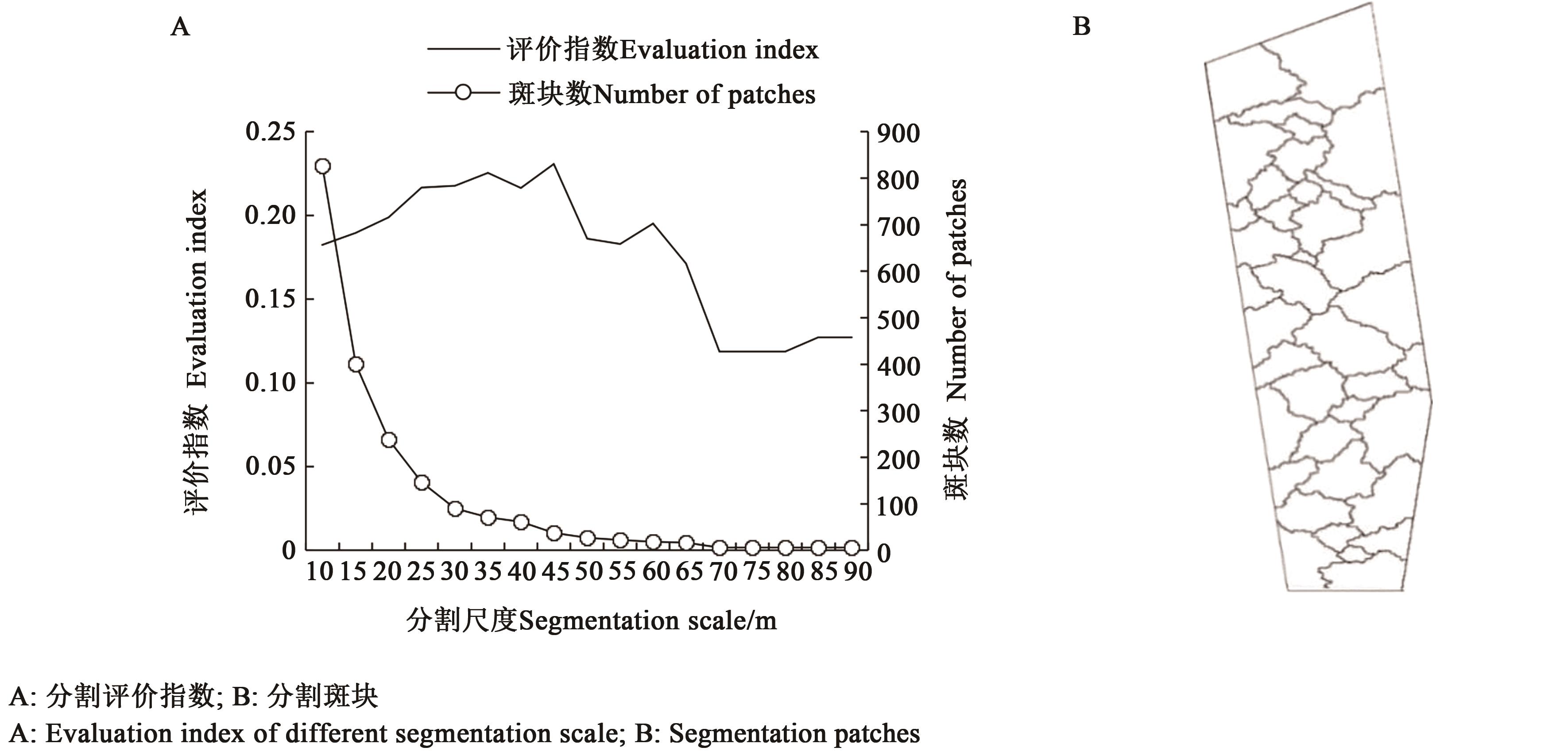
Fig. 2 Calculated Segmentation evaluation index and patches based on UAV images
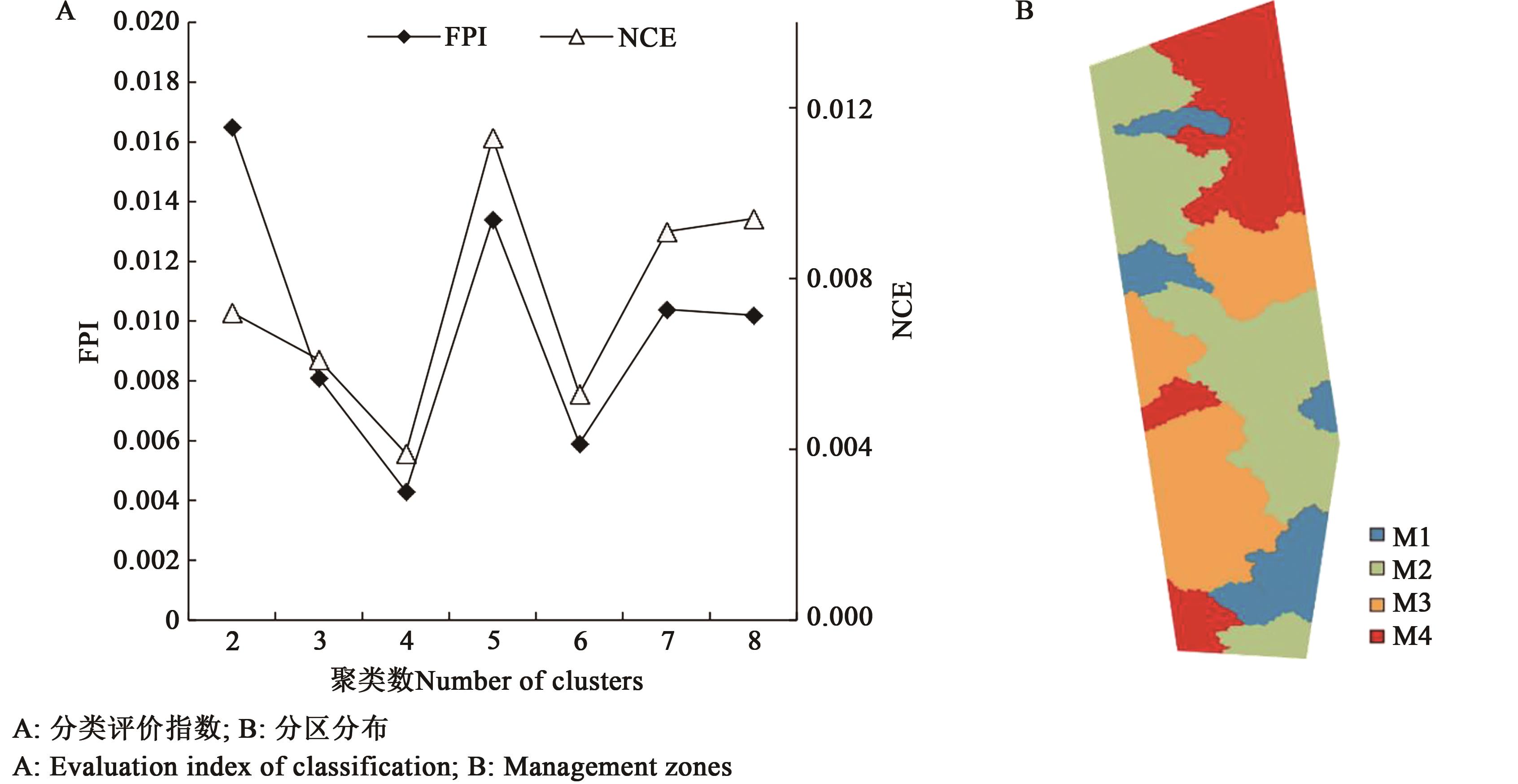
Fig. 3 Optimal management zones based on UAV images
| 主成分Principal component | 特征值Eigenvalue | 贡献率Contribution rate/% | 累积贡献率Accumulative contribution/% |
|---|---|---|---|
| PC1 | 2.45 | 34.95 | 34.95 |
| PC2 | 1.97 | 28.12 | 63.07 |
| PC3 | 1.77 | 25.22 | 88.29 |
| PC4 | 0.45 | 6.49 | 94.78 |
| PC5 | 0.20 | 2.91 | 97.69 |
| PC6 | 0.11 | 1.56 | 99.25 |
| PC7 | 0.05 | 0.75 | 100.00 |
Table 3 Principal Component analysis of soil variables and factor loadings
| 主成分Principal component | 特征值Eigenvalue | 贡献率Contribution rate/% | 累积贡献率Accumulative contribution/% |
|---|---|---|---|
| PC1 | 2.45 | 34.95 | 34.95 |
| PC2 | 1.97 | 28.12 | 63.07 |
| PC3 | 1.77 | 25.22 | 88.29 |
| PC4 | 0.45 | 6.49 | 94.78 |
| PC5 | 0.20 | 2.91 | 97.69 |
| PC6 | 0.11 | 1.56 | 99.25 |
| PC7 | 0.05 | 0.75 | 100.00 |
| 主成分Principal component | 有机质OM | 碱解氮AN | 有效磷AP | 速效钾AK | 土壤水分SWC | 电导率EC | pH |
|---|---|---|---|---|---|---|---|
| PC1 | 0.92 | 0.867 | 0.639 | 0.532 | -0.048 | -0.168 | -0.354 |
| PC2 | -0.216 | -0.409 | 0.709 | 0.688 | -0.348 | -0.021 | 0.61 |
| PC3 | 0.229 | -0.025 | 0.002 | 0.195 | 0.931 | 0.757 | 0.273 |
Table 4 Principal component factor loads
| 主成分Principal component | 有机质OM | 碱解氮AN | 有效磷AP | 速效钾AK | 土壤水分SWC | 电导率EC | pH |
|---|---|---|---|---|---|---|---|
| PC1 | 0.92 | 0.867 | 0.639 | 0.532 | -0.048 | -0.168 | -0.354 |
| PC2 | -0.216 | -0.409 | 0.709 | 0.688 | -0.348 | -0.021 | 0.61 |
| PC3 | 0.229 | -0.025 | 0.002 | 0.195 | 0.931 | 0.757 | 0.273 |
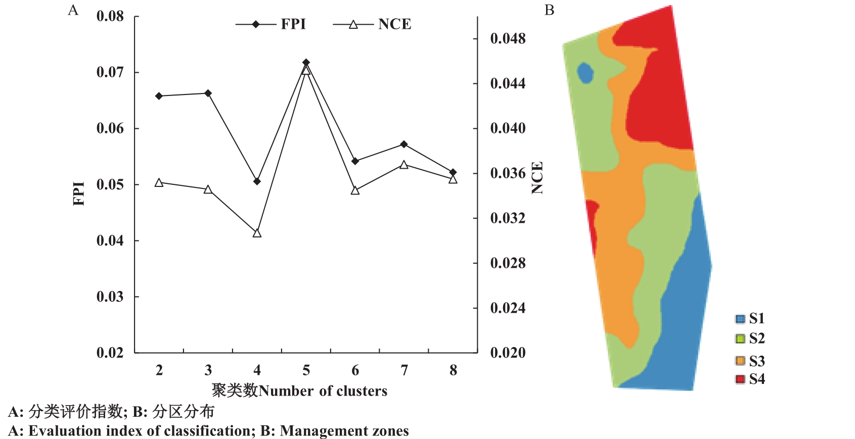
Fig. 4 Optimal management zones based on soil properties
| 分区方法Strategy | 样点重合率Similarity/% |
|---|---|
| M1-S1 | 40.00 |
| M2-S2 | 46.51 |
| M3-S3 | 57.45 |
| M4-S4 | 59.38 |
| M-S | 51.32 |
Table 5 Comparison of the percentage of points classified by different strategies
| 分区方法Strategy | 样点重合率Similarity/% |
|---|---|
| M1-S1 | 40.00 |
| M2-S2 | 46.51 |
| M3-S3 | 57.45 |
| M4-S4 | 59.38 |
| M-S | 51.32 |
分区 Zone | 样点数 Sample points No | i e l d /(kg·hm-2) 产量 Y | 有机质 OM/% | N /(mg·kg-1) 碱解氮 A | P /(mg·kg-1) 速效磷 A | K /(mg·kg-1) 速效钾 A | 水分 SWC/% | ||||||
|---|---|---|---|---|---|---|---|---|---|---|---|---|---|
| 均值 Mean | CV | 均值Mean | CV | 均值Mean | CV | 均值Mean | CV | 均值Mean | CV | 均值Mean | CV | ||
| M1 | 14 | 7 597.53 d | 13.52 | 5.71 c | 11.87 | 196.26 c | 10.57 | 62.45 c | 26.71 | 180.28 c | 16.62 | 31.28 a | 19.68 |
| M2 | 38 | 8 236.35 c | 13.66 | 6.31 b | 14.91 | 225.35 b | 18.66 | 82.16 b | 12.92 | 211.90 b | 15.09 | 30.28 a | 15.59 |
| M3 | 36 | 8 686.98 b | 13.39 | 6.78 a | 11.23 | 252.05 a | 10.12 | 91.12 a | 16.68 | 225.65 a | 12.99 | 29.21 a | 14.16 |
| M4 | 27 | 9 119.93 a | 15.61 | 7.03 a | 12.17 | 260.08 a | 13.05 | 93.99 a | 28.18 | 233.34 a | 15.88 | 29.48 a | 15.64 |
| S1 | 28 | 7 754.81 c | 15.39 | 5.90 d | 9.84 | 207.93 d | 11.21 | 69.30 d | 16.67 | 175.92 d | 11.38 | 27.96 c | 12.45 |
| S2 | 25 | 8 173.44 b | 14.84 | 6.28 c | 8.39 | 221.10 c | 13.36 | 77.93 c | 21.48 | 190.48 c | 16.52 | 33.13 a | 12.30 |
| S3 | 38 | 8 860.05 a | 14.36 | 6.76 b | 6.34 | 248.21 b | 5.99 | 91.25 b | 14.66 | 213.01 b | 12.33 | 28.44 c | 10.92 |
| S4 | 24 | 9 153.23 a | 13.61 | 7.26 a | 10.24 | 272.76 a | 8.41 | 102.42 a | 15.79 | 235.78 a | 14.71 | 30.81 b | 11.41 |
| 总计All | 115 | 8 507.1 | 16.23 | 6.55 | 17.41 | 237.98 | 19.57 | 85.34 | 32.07 | 210.60 | 19.53 | 29.81 | 16.37 |
Table 6 Variance analysis of spring maize yield and soil properties among management zones
分区 Zone | 样点数 Sample points No | i e l d /(kg·hm-2) 产量 Y | 有机质 OM/% | N /(mg·kg-1) 碱解氮 A | P /(mg·kg-1) 速效磷 A | K /(mg·kg-1) 速效钾 A | 水分 SWC/% | ||||||
|---|---|---|---|---|---|---|---|---|---|---|---|---|---|
| 均值 Mean | CV | 均值Mean | CV | 均值Mean | CV | 均值Mean | CV | 均值Mean | CV | 均值Mean | CV | ||
| M1 | 14 | 7 597.53 d | 13.52 | 5.71 c | 11.87 | 196.26 c | 10.57 | 62.45 c | 26.71 | 180.28 c | 16.62 | 31.28 a | 19.68 |
| M2 | 38 | 8 236.35 c | 13.66 | 6.31 b | 14.91 | 225.35 b | 18.66 | 82.16 b | 12.92 | 211.90 b | 15.09 | 30.28 a | 15.59 |
| M3 | 36 | 8 686.98 b | 13.39 | 6.78 a | 11.23 | 252.05 a | 10.12 | 91.12 a | 16.68 | 225.65 a | 12.99 | 29.21 a | 14.16 |
| M4 | 27 | 9 119.93 a | 15.61 | 7.03 a | 12.17 | 260.08 a | 13.05 | 93.99 a | 28.18 | 233.34 a | 15.88 | 29.48 a | 15.64 |
| S1 | 28 | 7 754.81 c | 15.39 | 5.90 d | 9.84 | 207.93 d | 11.21 | 69.30 d | 16.67 | 175.92 d | 11.38 | 27.96 c | 12.45 |
| S2 | 25 | 8 173.44 b | 14.84 | 6.28 c | 8.39 | 221.10 c | 13.36 | 77.93 c | 21.48 | 190.48 c | 16.52 | 33.13 a | 12.30 |
| S3 | 38 | 8 860.05 a | 14.36 | 6.76 b | 6.34 | 248.21 b | 5.99 | 91.25 b | 14.66 | 213.01 b | 12.33 | 28.44 c | 10.92 |
| S4 | 24 | 9 153.23 a | 13.61 | 7.26 a | 10.24 | 272.76 a | 8.41 | 102.42 a | 15.79 | 235.78 a | 14.71 | 30.81 b | 11.41 |
| 总计All | 115 | 8 507.1 | 16.23 | 6.55 | 17.41 | 237.98 | 19.57 | 85.34 | 32.07 | 210.60 | 19.53 | 29.81 | 16.37 |
| 1 | CRUZ C, SILVA J T, OCHO A, et al.. Delineation of environmental units by multivariate techniques in the duero river watershed, Michoacan, Mexico [J]. Environ. Model. Assess., 2016, 22(3):1-10. |
| 2 | 刘刚,闫静雯,谢云,等.黑土坡耕地土壤有机质空间变异及其与土壤侵蚀的关系——以黑龙江省鹤山农场为例[J].地理科学, 2016, 36(11): 1751-1758. |
| LIU G, YAN J W, XIE Y, et al.. Spatial variation of soil organic matter on black soil sloping cropland and its relationship with soil erosion: a case study of Heshan farm in Heilongjiang province [J]. Sci. Geographica Sin., 2016, 36(11): 1751-1758. | |
| 3 | OLDONI H, TERRA V, TIMM L C, et al.. Delineation of management zones in a peach orchard using multivariate and geostatistical analyses [J]. Soil Tillage Res., 2019, 191: 1-10. |
| 4 | GILI A, ALVAREZ C, BAGNATO R, et al.. Comparison of three methods for delineating management zones for site-specific crop management [J]. Comput. Electronics Agric., 2017, 139: 213-223. |
| 5 | 张泽,吕新,吕宁,等.基于GIS、RS的滴灌棉田土壤养分精确管理分区研究[J].农业机械学报,2014,45(7):125-132. |
| ZHANG Z, LV X, LV N, et al.. Defining agricultural management zones using remote sensing and GIS techniques for drip-irrigated cotton fields [J]. Trans. Chin. Soc. Agric. Mach.., 2014, 45(7): 125-132. | |
| 6 | BREUNIG F M, GALVAO L S, DALAGNOL R, et al.. Delineation of management zones in agricultural fields using cover-crop biomass estimates from PlanetScope data [J/OL]. Int. J. Appl. Earth OBS, 2020, 85: 102004 [2022-05-27]. . |
| 7 | KUIAWSKI A C, SAFANELLI J L, BOTTEGA E, et al.. Vegetation indexes and delineation of management zones for soybean [J]. Pesqui. Agrop. Trop., 2017, 47(2): 168-177. |
| 8 | 乔浪,张智勇,陈龙胜,等.基于无人机图像的玉米冠层叶绿素含量检测与分布研究[J].农业机械学报,2019,50:182-186. |
| QIAO L, ZHANG Z Y, CHEN L S, et al.. Chlorophyll content detection and distribution research of maize canopy based on UAV image [J]. Trans. Chin. Soc. Agric. Mach., 2019, 50: 182-186. | |
| 9 | 韩文霆,彭星硕,张立元,等.基于多时相无人机遥感植被指数的夏玉米产量估算[J].农业机械学报,2020,51(1):149-155. |
| HAN W T, PENG X S, ZHANG L Y, et al.. Summer maize yield estimation based on vegetation ondex derived from multitemporal UAV remote sensing [J]. Trans. Chin. Soc. Agric. Mach., 2020,51(1):149-155. | |
| 10 | LEROUX C, JONES H, CLENET A, et al.. A new approach for zoning irregularly-spaced, within-field data [J]. Comput. Electron. Agric., 2017,141:196-206. |
| 11 | BENZ U C, HOFMANN P, WILLHAUCK, et al.. Multi-resolution, object-oriented fuzzy analysis of remote sensing data for GIS-ready information [J]. ISPRS-J. Photogramm. Remote Sens., 2004,58(3-4): 239-258. |
| 12 | 马龙飞,胡乃月,李伟,等.利用无人机多光谱数据监测玉米对不同灌溉模式的响应差异[J]. 植物营养与肥料学报,2022,28(4):743-753. |
| MA L F, HU N Y, LI W, et al.. Using multispectral drone data to monitor maize's response to various irrigation modes [J]. J. Plant Nutr. Fert., 2022,28(4):743-753. | |
| 13 | 田庆久.植被指数研究进展[J].地球科学进展,1998,13(4):328-333. |
| TIAN Q J. Advances in study on vegetation indices [J]. Adv. Earth Sci., 1998, 13(4):328-333. | |
| 14 | 陈春雷,武刚.面向对象的遥感影像最优分割尺度评价[J].遥感技术与应用,2011,26(1):96-102. |
| CHEN C L, WU G. Evaluation of optimal segmentation scale with object-oriented method in remote sensing [J]. Remote Sen. Technol. Appl., 2011, 26(1):96-102. | |
| 15 | 王露,刘庆元.面向对象的高分辨率遥感影像多尺度分割参数及分类研究[J].测绘与空间地理信息,2015,38(3):167-169. |
| WANG L, LIU Q Y. The methods summary of optimal segmentation scale selection in high resolution remote sensing images multiscale segmentation [J]. Geomatics Spatial Inf. Technol., 2015, 38(3): 167-169. | |
| 16 | GAVIOLI A, SOUZA E G, BAZZI C L, et al.. Optimization of management zone delineation by using spatial principal components [J]. Comput. Electron. Agric., 2016. 127: 302-310. |
| 17 | FRIDGEN J J, NEWELL R, KITCHEN, et al.. Management zone analyst (MZA): software for subfield management zone delineation [J]. Agron. J., 2004. 96(1): 100-108. |
| 18 | 刘建刚,赵春江,杨贵军,等.无人机遥感解析田间作物表型信息研究进展[J].农业工程学报,2016,32(24):98-106. |
| LIU J G, ZHAO C J, YANG G J, et al.. Review of field based phenotyping by unmanned aerial vehicle remote sensing platforrm [J]. Trans. Chin. Soc. Agric. Eng., 2016, 32(24): 98-106. | |
| 19 | CHANG D, ZHANG J, ZHU L, et al.. Delineation of management zones using an active canopy sensor for a tobacco field [J]. Comput. Electron. Agric., 2014, 109: 172-178. |
| 20 | LI F, MIAO Y X, FENG G H, et al.. Improving estimation of summer maize nitrogen status with red edge-based spectral vegetation indices [J]. Field Crops Res., 2014, 157: 111-123. |
| 21 | 赵明明.基于无人机与卫星影像的农田精准管理分区研究[D].哈尔滨:东北农业大学,2019. |
| ZHAO M M. Study on site-specific management zones in field using unmanned aerial vehicle and satellite images [D]. Harbin: Northeast Agricultural University, 2019. | |
| 22 | 任佰朝,张吉旺,董树亭,等.生育前期淹水对夏玉米冠层结构和光合特性的影响[J].中国农业科学,2017,50(11):2093-2103. |
| REN B C, ZHANG J W, DONG S T, et al.. Effect of waterlogging at early period on canopy structure and photosynthetic characteristics of summer maize [J]. Sci. Agric. Sin., 2017, 50(11): 2093-2103. | |
| 23 | 葛翠萍,赵军,王秀峰,等.东北黑土区坡耕地地形因子对土壤水分和容重的影响[J].水土保持通报,2008,28(6):16-21. |
| GE C P, ZHAO J, WANG X F, et al.. Influence of topographic factors on soil water and bulk density in a typical slope land in the black soil area of Northeast China [J]. Bull. Soil Water Conser., 2008, 28(6): 16-21. |
| [1] | Kuiyuan CHEN, Hui LIU, Wei DING. Effect of Glyphosate on Soil Nutrient and the Functional Enzyme Activities in Soybean Fields [J]. Journal of Agricultural Science and Technology, 2022, 24(5): 180-188. |
| [2] | Zhenjia HE, Wangtao FAN, Yichun DU, Qilong WANG. Effects of Water and Fertilizer Coupling on the Physical and Chemical Properties of Rice Soil and Yield Based on Soil Organic Reconstruction [J]. Journal of Agricultural Science and Technology, 2022, 24(3): 176-185. |
| [3] | Lijuan HE, Zhongju MENG, Xiaohong DANG, Tao LYU. Effects of Planting Glycyrrhizauralensis on Mechanical Composition and Nutrients of Aeolian Sandy Soil [J]. Journal of Agricultural Science and Technology, 2022, 24(2): 169-176. |
| [4] | FAN Hongye, LI Yaoyao, LU Xiaju, GU Shenghao, GUO Xinyu, , LIU Yuhua. [J]. Journal of Agricultural Science and Technology, 2021, 23(9): 112-120. |
| [5] | ZHANG Guanhong, WANG Xinjun, XU Xiaolong, YAN Linan, CHANG Mengdi, LI Yongkang, . Desert Vegetation Classification Based on Object-oriented UAV Remote Sensing Images [J]. Journal of Agricultural Science and Technology, 2021, 23(5): 69-77. |
| [6] | FU Rongtao, CHEN Cheng, WANG Jian, CHEN Xuejuan, LU Daihua*. Control Conditions and Effects of Plant Protection Unmanned Aerial Vehicle (UAV) on Diseases and Insect Pests of Rice#br# [J]. Journal of Agricultural Science and Technology, 2021, 23(4): 103-109. |
| [7] | ZHOU Kai1, ZHOU Tong1, DING Feng2, DING Dawei2, WU Wei1, YAO Zhaosheng1, LIU Tao1, HUO Zhongyang1, SUN Chengming1*. Wheat LAI Estimation in Main Growth Period Based on UAV Images [J]. Journal of Agricultural Science and Technology, 2021, 23(1): 89-97. |
| [8] | PU Quanming1, YANG Peng1*, DENG Yuchuan2, XIANG Chengyong1, LIN Bangmin1, LIU Lisha1, SHI Songmei3, HE Zemin1, YONG Lei1. Effects of Different Fertilization Methods on Soil Enzyme Activity, Soil Nutrients and Quality of Spring Cabbage [J]. Journal of Agricultural Science and Technology, 2020, 22(7): 130-139. |
| [9] | LIANG Yugang1, LI Jingyi1, WANG Dan2, YU Zhengjun1, HUANG Huang1*, CHEN Can1*. Impact of Rice-fish-chicken Ridge Cultivation on Rice Population Growth and Yield [J]. Journal of Agricultural Science and Technology, 2020, 22(11): 165-175. |
| [10] | WANG Bingjie1, PAN Bo1, JIANG Lei1, LIN Yong1*, ZHAO Shuai2, MO Yuxing2. Effects of Spraying Parameters of Plant Protection Unmanned Aerial Vehicle on Deposition Distribution of Droplets in Pitaya Canopy [J]. Journal of Agricultural Science and Technology, 2020, 22(10): 101-109. |
| [11] | XU Peng1, XU Weicheng2, LUO Yangfan2, ZHAO Zuoxi2*. Precise Classification of Cultivated Land Based on Visible Remote Sensing Image of UAV [J]. Journal of Agricultural Science and Technology, 2019, 21(6): 79-86. |
| [12] | XU Weicheng1, CHEN Kai1, ZHANG Ming1, LI Zhengfeng2, ZHANG Tianshun1*. Life Lifting Scheme for Plant Protection UAV Based on Solar [J]. Journal of Agricultural Science and Technology, 2018, 20(11): 62-68. |
| [13] | SUN Ze-dong, MA Xing-hua*. Research Progress on Effects of Drip Fertilization on Plant Growth and Soil Nitrogen Characteristics [J]. Journal of Agricultural Science and Technology, 2016, 18(5): 164-170. |
| [14] | WANG Jianping1, SUN Wenxin2*, SU Linmeng1. Crop Growth Simulation Based on WebGIS Integrated with SALUS [J]. , 2013, 15(5): 120-128. |
| [15] | LV Chuan-gen1, HU Ning2, YAO Ke-min2, ZOU Jiang-shi1. Ecotype Model Analysis on Crop Growth Rate of Two-Line Hybrid Rice, Liangyoupeijiu (Oryza Sativa) [J]. , 2010, 12(4): 62-67. |
| Viewed | ||||||
|
Full text |
|
|||||
|
Abstract |
|
|||||
 京公网安备11010802021197号